Skip to content

Safeguarding Our Nation's Critical Infrastructure: The Role of Dams and Modern Dam Safety

Introduction:
Dams are foundational to modern society, strategically managing our most vital resource: water. These essential structures provide drinking water, generate renewable energy, and mitigate flood risks, directly impacting both community prosperity and environmental health. This blog explores the critical mission of the Federal Emergency Management Agency’s (FEMA) National Dam Safety Program (NDSP) and examines how advanced geospatial analytics from Nazru are empowering states to enhance safety protocols and secure crucial federal funding.
The Multifaceted Value of America’s Dams

With over 90,000 dams cataloged by the U.S. Army Corps of Engineers, this infrastructure forms the backbone of regional water security and economic stability. Their functions are indispensable:

Water Security: Ensuring a reliable supply of water for municipal, agricultural, and industrial use.

Renewable Energy: Serving as a key source of hydroelectric power, reducing reliance on fossil fuels.

Flood Mitigation: Regulating water flow to protect downstream communities and properties from catastrophic damage.

Economic & Recreational Hubs: Creating reservoirs that support tourism, recreation, and local ecosystems, thereby boosting regional economies.

The Critical Need for Proactive Dam Safety

The benefits of dams are matched by the profound risks associated with their failure. Inadequate maintenance or structural deficiencies can lead to tragic loss of life, extensive property damage, and severe environmental harm.

The data is sobering. The Association of State Dam Safety Officials reports that from 2005 to 2013, the U.S. experienced over 170 dam failures and hundreds of near-miss incidents. A more recent example, the 2020 collapse of Michigan’s Edenville Dam following heavy rains, forced the evacuation of 10,000 residents and caused damages estimated in the hundreds of millions of dollars.


In response to these risks, FEMA’s National Dam Safety Program (NDSP) is instrumental in providing states with the technical assistance and funding needed to strengthen dam infrastructure.

Nazru supports this vital mission by providing high-precision, AI-powered geospatial data. Our solutions enable state agencies to accurately map, assess, and monitor dam infrastructure and downstream communities, creating the robust, data-driven applications required to access NDSP and other federal funding streams. By leveraging this technology, states can more effectively prioritize repairs, minimize risks, and fulfill their commitment to public safety.

Lock and Dam No. 15, located on the Mississippi River at Rock Island, is a cornerstone of the region’s economic and industrial framework. Its primary mission is to support a robust and efficient navigation system.

By providing a stable and deep-water channel, this facility ensures the uninterrupted flow of maritime commerce. It allows for the efficient movement of critical goods, connecting the heartland of America to national and global markets. The dam also plays a key role in managing the river’s hydrology, making it a vital asset for regional stability and water resource management.

The National Dam Safety Program (NDSP): A Foundation for National Infrastructure Security

Safeguarding the nation’s dam infrastructure through rigorous safety protocols and proactive maintenance is a paramount objective for state authorities. The Federal Emergency Management Agency’s (FEMA) National Dam Safety Program (NDSP) is instrumental in this national endeavor, providing critical leadership and resources to mitigate risks to communities, property, and the environment.

A cornerstone of the NDSP is its State Assistance Grant Program, which allocates federal funding to states and territories. These grants are designed to empower state-level dam safety initiatives, with a strategic focus on enhancing the structural integrity, operational security, and overall performance of dams.

Dams form a critical line of defense and a source of sustenance for cities nationwide. Guaranteeing their safety is synonymous with protecting the lives, livelihoods, and infrastructure of the communities they serve.

A comprehensive and precise geospatial inventory of dams is a foundational element of modern dam safety and a critical prerequisite for securing federal funding for safety enhancements. Such an inventory enables the accurate mapping and systematic classification of dams according to their specific location and, most importantly, their proximity to high-consequence areas, such as residential zones or critical infrastructure. This data empowers state and federal agencies to effectively prioritize dams that require immediate intervention based on the potential risk to human life, property, and essential services downstream. The capacity to rapidly identify high-hazard potential dams ensures that limited funding can be directed toward the most urgent mitigation projects, while also guaranteeing that all structures are properly cataloged, categorized, and monitored—a vital requirement for both safety planning and FEMA funding eligibility.

However, the task of creating and maintaining an accurate dam inventory, complete with current risk proximity assessments, presents a significant challenge for states. The dynamic nature of urban development, population expansion, and evolving environmental conditions causes the risk landscape to shift rapidly, often rendering existing dam classifications and inventories obsolete.

Modernizing Dam Mapping with Nazru’s AI-Powered Solutions

As communities continue to evolve, statewide geospatial databases can quickly become outdated. The traditional process of manually digitizing features from imagery into vector layers is notoriously resource-intensive and slow. This method is inefficient, regardless of scale, and struggles to keep pace with change. For instance, the GIS team in Collier County, Florida, required nearly four years to manually digitize driveways across the county—by the time the project was completed, the data no longer fully represented the current reality. For dam safety, where surrounding environments are in constant flux, this challenge is magnified, making it exceptionally difficult to maintain an accurate, real-time understanding of associated risks.

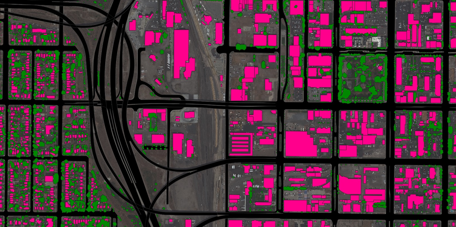
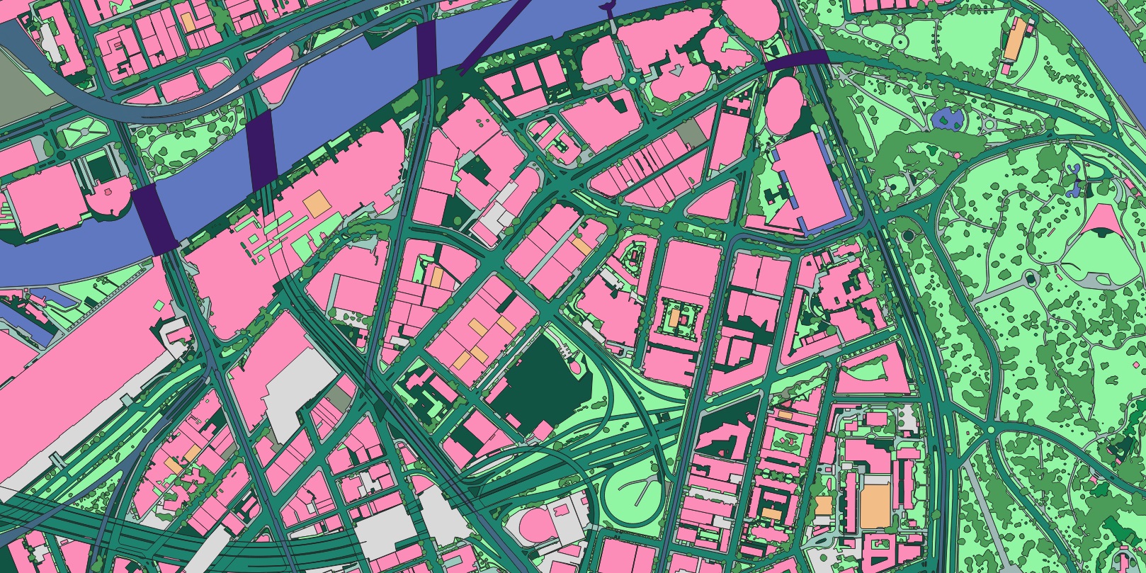
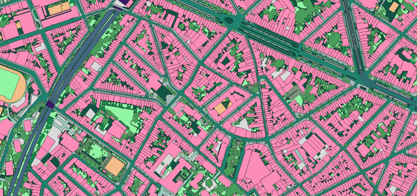
Nazru provides a sophisticated and efficient solution to this challenge. Our advanced, AI-based mapping systems are capable of automatically detecting and extracting every feature captured in source imagery—both natural and man-made—and classifying them into distinct, high-precision vector layers depicting critical landscape and infrastructure elements. Tasks that once demanded months of labor from trained GIS professionals can now be accomplished in a fraction of the time. In fact, our systems can extract comprehensive, high-precision vector data from imagery for an entire state within weeks.

With Nazru’s data, states can efficiently establish and maintain a current inventory of dams and their surrounding land cover. This ensures decision-makers always have access to the most up-to-date information. Furthermore, they can systematically assess proximal hazards to support accurate dam classification and risk assessment. What was once an incredibly time-consuming manual process can now be executed with unparalleled speed and precision, empowering officials with the actionable data needed to effectively manage and mitigate risks.

Case in Point: Nazru partnered with the Government of Canada to map over 1,100 square miles of land cover and infrastructure in the greater Montreal area. The project delivered high-precision vector data on impervious surfaces, natural water features, dams, and dikes, providing critical insights to bolster flood management and disaster resilience initiatives for the region.

Dams form a critical line of defense and a source of sustenance for cities nationwide. Guaranteeing their safety is synonymous with protecting the lives, livelihoods, and infrastructure of the communities they serve.

Building
Road
Driveway
Water
Pavement
Bridge
Sidewalk
Bareland
Shrub
Forest
Parking
Grass
Bike-lane
Dam
Dike
Crosswalk
Unpaved-road
Railway