Skip to content

Scaling Geospatial Data Creation for National & Regional GIS Operations

Governments across Europe have long relied on Geographic Information Systems (GIS) to inform decision-making on crucial issues related to infrastructure, the environment, and the well-being of their citizens. However, acquiring, creating, and maintaining the data to fuel these geospatial analysis workflows remains a significant challenge in our dynamically changing world.

Fortunately, innovation in both technology and how public administrations approach GIS has paved the way for more accessible and reliable geospatial analytics. Furthermore, EU funding programmes offer the financial resources to create and maintain national-scale geospatial data repositories, supporting a wide range of applications in climate resilience, transportation planning under the Trans-European Transport Network (TEN-T), and environmental monitoring for directives like the EU Green Deal.

In a recent webinar, a former president of EuroGeographics and a senior GI expert from a European member state joined Nazru’s experts to discuss real-world case studies from public agencies across Europe that are using high-precision mapping data to enhance critical infrastructure projects related to climate resilience and sustainable development. The conversation also included information about available EU funding opportunities. We’ve summarized key takeaways from the discussion here.

The Power of Geospatial Data in Addressing National GIS Challenges

The webinar began with an emphasis on the critical importance of high-precision geospatial data to understand climate vulnerabilities and inform decision-making related to how an organization might plan, fund, and build resilience for both natural and built environments. The discussion highlighted how Nazru collaborates with governments at all levels to create comprehensive, up-to-date, and accurate geospatial data to support various initiatives, including flood mitigation, public safety, and transportation planning.

Nazru’s experts elaborated on the company’s solutions, explaining that its AI-based technology ingests high-resolution geospatial imagery to extract comprehensive land cover data. This results in a complete digital representation of critical infrastructure and natural features with the accuracy of a trained GIS professional, but at the speed and scale needed for rapidly changing environments. The conversation explored the important role of this data in preparing for and responding to significant challenges facing European nations today, including flooding, extreme heat, wildfires, and urbanisation.

Flood Mitigation and Climate Adaptation

The discussion highlighted the substantial risk that coastal surges and inland flooding pose to communities throughout Europe. Drawing attention to recent devastating floods in regions like the Ahr Valley in Germany and parts of Belgium, the speakers underscored the urgency of leveraging geospatial data to understand, quantify, and ultimately mitigate the threats posed by flooding. They emphasized the significance of having high-precision data related to impervious and pervious surfaces, natural vegetation cover, and elevation to assess risks and address challenges associated with the high-intensity storms that are becoming more frequent due to climate change.

This data is crucial for enhancing the accuracy of flood forecasting models, prioritising investments in protective infrastructure, and ensuring compliance with the EU’s Floods Directive. By allocating resources based on precise, data-driven risk assessments, governments can build more resilient communities.

Flooded streets in Jacksonville, Florida in the aftermath of Hurricane Irma, a storm that caused record-breaking flooding in the city. (Reference)

Urban Heat Islands

The discussion then turned to the impacts of the urban heat island effect on European communities, which include increased energy consumption, adverse health effects—particularly for the elderly and vulnerable populations—and elevated emissions. Acknowledging extreme heat as a growing cause of weather-related mortality across Europe, the speakers highlighted that urban heat effects are often disproportionately concentrated in socio-economically disadvantaged communities.

Geospatial data layers play a crucial role in addressing this challenge by helping to identify communities most at risk. By analysing the relationship between vegetation canopy coverage, impervious surfaces, and land surface temperatures, cities can pinpoint areas for intervention. However, open-source land cover data is often too coarse or outdated for effective, hyper-local analysis.

The Nazru team stressed the importance of detailed, accurate, and up-to-date geospatial data for comprehensive risk assessment and vulnerability mapping. Such data is indispensable for guiding targeted interventions, such as strategic tree planting programmes, the development of green corridors, and the planning of cool-roof initiatives, as supported by EU strategies like the EU Climate Adaptation Mission.

Wildfires

To conclude the summary of key natural hazards facing European nations, the focus shifted to another escalating risk: wildfires. Wildfires are growing in frequency, intensity, and geographic spread across Southern and now even Central and Northern Europe, threatening communities, vital ecosystems, and local economies. Recent catastrophic fires in countries like Greece, Spain, and Portugal have demonstrated the severe human and financial costs.

High-quality geospatial data is vital for all phases of wildfire management. It is used to assess fuel loads by accurately mapping forests, shrublands, and grasslands, which directly influence fire behaviour and spread potential. Furthermore, the Nazru experts highlighted the critical role of highly accurate data in emergency response preparedness—from modelling fire propagation and identifying optimal evacuation routes to rapidly assessing the extent of damage for post-disaster recovery efforts through the EU’s Copernicus Emergency Management Service

An image of California veiled in an orange haze following the wildfires in 2020. (Reference)

Population Growth & Urbanisation

The session then shifted to discuss how, in addition to natural hazards, rapid population growth and urbanisation pose significant challenges for European member states and regions. Projections indicate that urban areas in Europe will continue to concentrate a growing majority of the population, intensifying the strain on existing infrastructure. This trend is already exerting considerable pressure on transportation networks. Major urban centres are struggling to move people and goods efficiently, leading to increased congestion, diminished quality of life for residents, and economic impediments due to delays in the logistics and supply chains.

Furthermore, the increase in population density, with more vehicles, pedestrians, and cyclists sharing constrained urban space, elevates commuting risks and contributes to road safety concerns. A critical point highlighted was the disparity in access to efficient and safe transportation, which can further marginalise vulnerable communities. The discussion underscored the urgent need for significant infrastructure improvements to ensure pedestrian safety, address accelerated infrastructure wear and tear, and accommodate heightened demand in a sustainable manner.

National GIS Case Study Examples

Following the assessment of key challenges, examples were shared demonstrating how public authorities have collaborated with Nazru to leverage geospatial data for enhancing critical infrastructure related to climate resilience and urban management. Here is a breakdown of a representative case study.

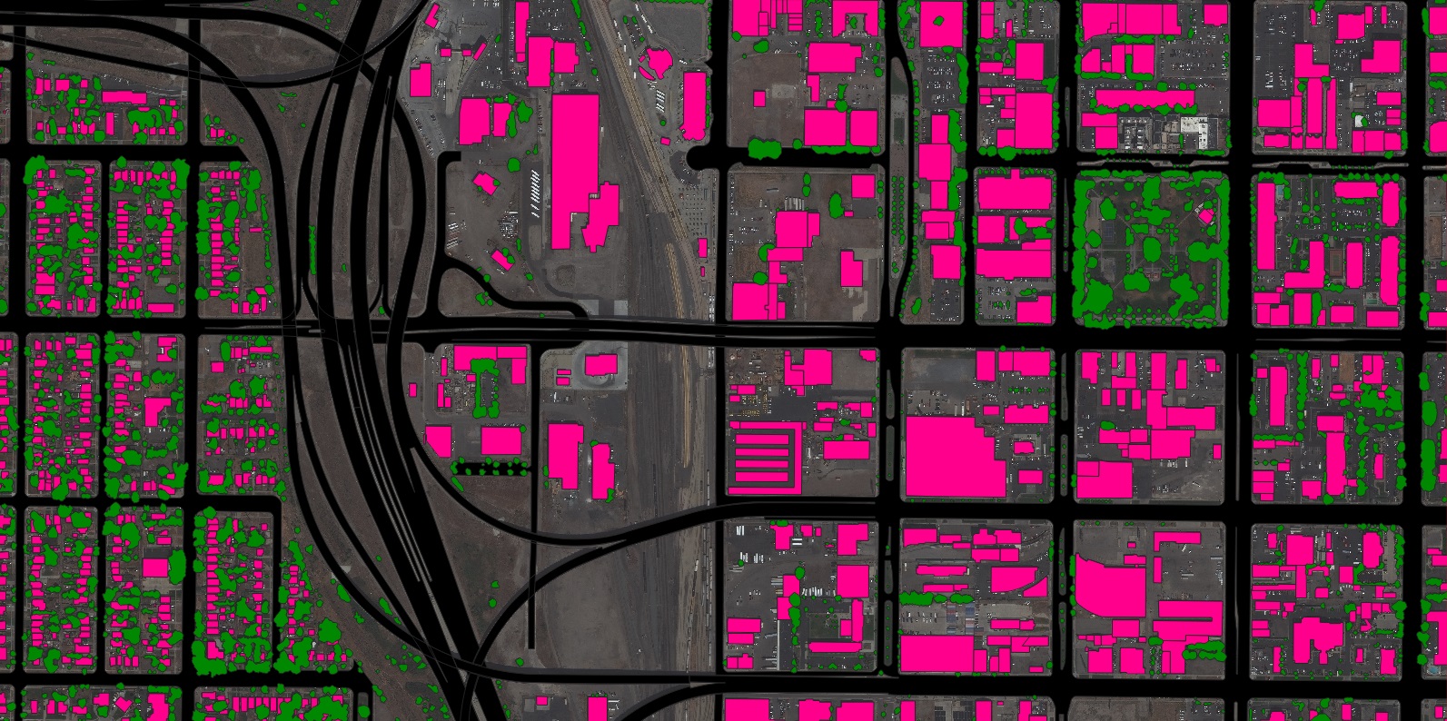
Creating a Comprehensive Road & Bridge Inventory for a European National Road Authority

In this case study, the focus was on a European country with a transport network significantly exposed to climate-related disasters. A primary challenge was the absence of a detailed, up-to-date inventory of road and bridge assets, which hampered effective emergency response planning. Variables such as elevation, rainfall, and potential water runoff often lead to submerged and impassable infrastructure during extreme weather events.

In partnership with a national road authority and a leading research university, Nazru utilised its AI-based systems to extract highly detailed road features and bridge inventories across a vast region. This involved creating a precise road elevation model that accounts for the precise height of bridges and roads. This dataset enables the authority to identify which infrastructure is most at risk during major natural disasters and to understand which routes remain safe for emergency services. The resulting model supports a superior understanding of critical infrastructure and facilitates the creation of accurate, real-time flood inundation maps. This capability allows the road authority to transition to a proactive flood response strategy and provide more reliable and timely flood information to citizens and communities.

A sample of the detailed impervious and pervious surface features extracted by Nazru AI for a national transport agency in a Santiago, Chile urban area, enabling climate-resilient infrastructure planning.
Road
Bridge

Understanding Climate Resilience Equity with Data from the European Environment Agency and Eurostat

The presentation detailed how the Nazru team leveraged high-precision land cover data, created using pan-European reference data, to examine climate resilience equity in a major European metropolitan area.

Analyzing an extensive urban region, Nazru used comprehensive, accurate, and up-to-date land cover vector layers to understand the spatial relationship between socio-economic factors—such as income levels and poverty indices from Eurostat—and environmental features like tree canopy coverage and impervious surfaces, informed by data from the European Environment Agency (EEA).

By integrating Nazru’s vector layers with publicly available census data, a direct correlation was identified: neighbourhoods in the lowest income quintile exhibited a significantly higher average percentage of impervious land cover compared to those in the highest income quintile. This disparity is critically important, as impervious surfaces not only exacerbate flood risks during extreme precipitation events but also intensify the Urban Heat Island effect, a growing cause of weather-related mortality across Europe.

The outcome of this analysis is a targeted, data-driven understanding of social and environmental disparities within the urban fabric. This serves as a vital evidence base for policymakers to guide equitable climate adaptation initiatives, ensuring that resilience-building efforts are directed towards the communities most vulnerable to climate impacts.

Road
Pavement
Driveway
Forest
Water
Sidewalk
Parking
Sport-ground
Bareland
Grass
Building
Railway
Unpaved-road
Unpaved-sport-ground
 A sample of the advanced land cover features extracted by Nazru in Dresden, germany for an in-depth climate resilience analysis.

Scaling Pedestrian Network Analysis for a European National Transport Authority

The discussion then presented a case study related to Nazru’s partnership with a European national transport authority to support sustainable urban mobility planning in regions across the country.

Focusing on a major metropolitan planning organisation (MPO), the presentation explained that the MPO sought to enhance pedestrian infrastructure and ensure compliance with the European Accessibility Act across one of the EU’s most populous urban areas. After its staff spent a significant amount of time manually digitizing transportation features with limited coverage, the MPO required a more efficient and scalable solution.

To support this and other regional authorities, the national transport ministry selected Nazru to create a comprehensive, standardized map of pedestrian transportation features. Nazru’s AI-powered systems generated a complete pedestrian infrastructure network map across the entire specified region—covering thousands of square kilometers—achieving unprecedented efficiency while maintaining the high accuracy required for regulatory and planning purposes.

This foundational dataset included detailed features such as sidewalk centerlines and edges with width attribution, enabling planners to systematically identify critical gaps in the pedestrian network. Beyond core sidewalks, Nazru delivered additional features such as dedicated bike lanes, tactile paving surfaces, medians, and crosswalks. This provides a holistic understanding of the active transportation infrastructure.

The presentation concluded by highlighting the critical role this data plays in supporting compliance with the European Accessibility Act, advancing the goals of the EU’s Road Safety Policy Framework towards Vision Zero, and fundamentally promoting pedestrian safety and equitable access to transportation across the region.

 A sample of the detailed land cover features extracted by Nazru AI in Eppinghofen, Germany.
Road
Pavement
Crosswalk
Raised-median
Slip-turn-lane
Driveway
Bridge
Forest
Left-turn-lane
Palnting-strip
Water
Sidewalk
Parking
Right-turn-lane
Stop-controlled-intersection
Sport-ground
Bareland
Grass
Stop-line
Signal-controlled-intersection
Building
Railway
Painted-median
Through-lane
Uncontrolled-intersection

Funding Opportunities for National Geospatial Programmes

The next portion of the discussion focused on how national and regional governments can leverage EU funding opportunities to support the creation of scalable, high-precision geospatial data. While historical funding challenges were acknowledged, it was noted that financial support has become increasingly accessible through key EU initiatives. Specific examples of relevant EU funding programmes were then highlighted.

Connecting Europe Facility (CEF) – Transport

The core objective of the Connecting Europe Facility (CEF) for Transport is to build and modernise sustainable, efficient, and resilient trans-European transport networks. A significant portion of its funding is dedicated to enhancing the climate resilience of transport infrastructure. This includes supporting projects that address vulnerabilities to natural hazards such as flooding, sea-level rise, and other extreme weather events. Funding can be allocated to:

  • Studies and Planning: Developing comprehensive risk assessments and resilience plans for transport corridors, requiring a detailed understanding of existing assets and future climate projections.

  • Works and Deployment: Implementing physical resilience improvements to infrastructure identified as “at-risk” in the aforementioned plans, such as reinforcing bridges, improving drainage, and protecting coastal routes.

EU Road Safety Framework & Regional Development Funds

Aligned with the EU’s ambitious Road Safety Policy Framework and its goal of moving towards “Vision Zero,” various funding streams, including the Cohesion Fund and the European Regional Development Fund (ERDF), can support safer road infrastructure. The first step is often the development of a data-driven Strategic Road Safety Plan.

This requires a detailed, accurate understanding of the existing road infrastructure to identify high-risk locations. Key data points include intersection design, sidewalk continuity, cycling lane availability, and the presence and quality of crosswalks. By systematically identifying these risk factors, authorities can effectively plan and prioritise infrastructure adaptations to significantly increase safety for all road users.

EU Mission: Climate-Neutral and Smart Cities & Just Transition Fund

Finally, EU missions and funds, such as those underpinning the Climate-Neutral and Smart Cities Mission and the Just Transition Fund, are explicitly designed to promote equity and address historical disparities. These programmes aim to help cities and regions improve social equity while advancing climate goals.

Competitive grants under these initiatives emphasise assisting disadvantaged or underserved communities with planning and capacity building. Eligible activities often include:

  • Identifying and assessing environmental challenges such as air quality, urban heat islands, and gaps in green infrastructure.

  • Mapping flood-prone transportation infrastructure.

  • Conducting comprehensive transportation equity and pollution impact assessments.

Harnessing Geospatial Data to Create More Resilient and Equitable Communities

From coastal flooding and extreme heat to urbanisation pressures, European governments are tasked with solving complex, interconnected challenges. Comprehensive, accurate, and up-to-date geospatial data provides the foundational evidence base for assessing climate risks and infrastructure vulnerabilities. This data directly informs strategic planning efforts to build resilience, promote equity, and ensure sustainable development.

Nazru’s advanced, AI-derived geospatial data is empowering decision-makers with the critical information they need today to prepare for the challenges of tomorrow. Combined with accessible EU funding opportunities, this data is paving the way for Member States and regions to create a more resilient, sustainable, and equitable future for all citizens.

To learn more about how AI-powered geospatial data can support your initiatives, get in touch with the Nazru team.