Navigating Modern Stormwater Management with Geospatial Solutions
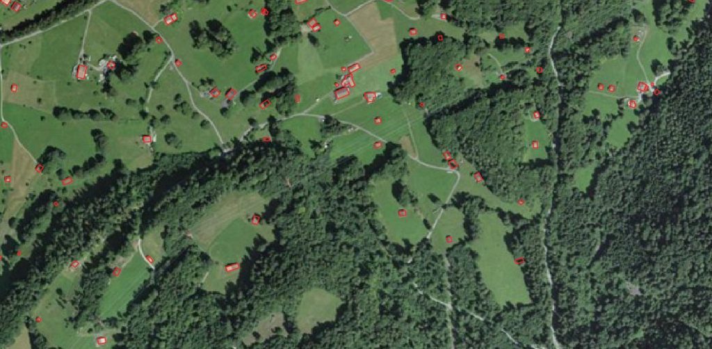
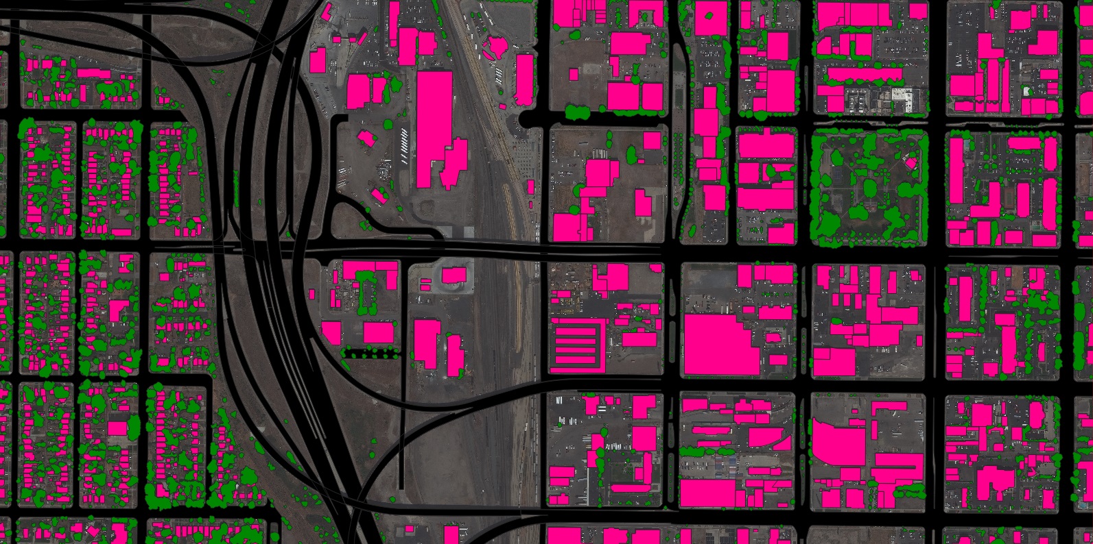
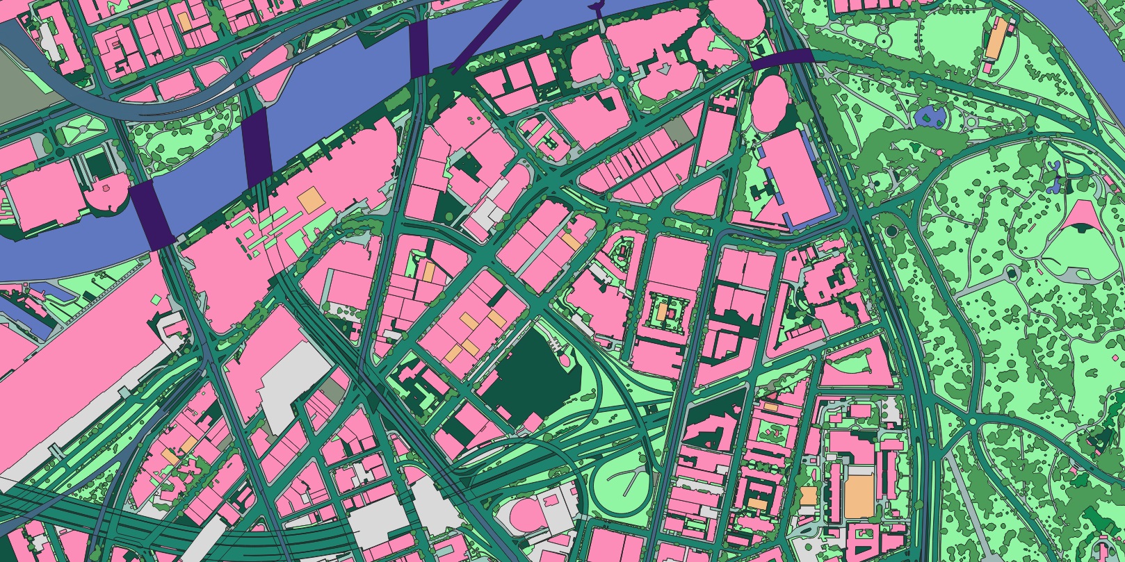
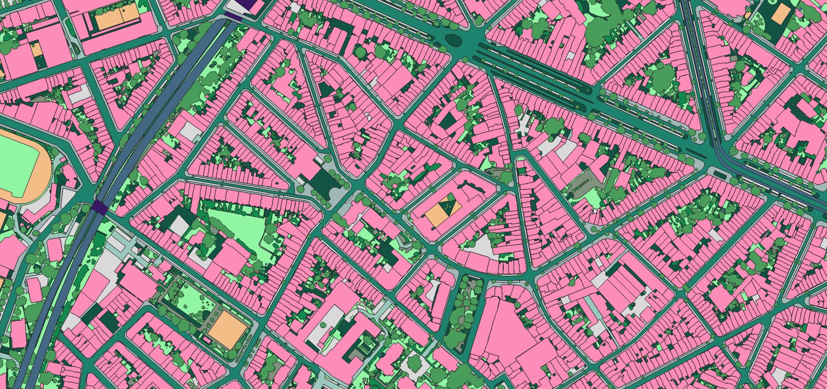
Climate change, land development, population movements, and other dynamic global factors are driving governments at all levels to adopt advanced geospatial solutions for stormwater management. At Nazru AI, we collaborate with municipalities and federal agencies worldwide to create a reliable source of truth for land cover features critical to stormwater infrastructure and planning. Our highly detailed classifications of impervious, pervious, and unpaved compacted surfaces empower decision-makers to adapt their strategies to an ever-evolving world.
Through our extensive work across the public sector, we have engaged with numerous stormwater mapping initiatives. While each government entity has unique needs, most projects follow a similar workflow. To support agencies seeking to enhance their use of geospatial data for impervious surface and stormwater mapping, we have developed this checklist based on proven approaches from government clients globally.
1. Define Your Objectives
Before launching any project, stakeholders must align on a clear end goal. For stormwater mapping, common objectives include:
Optimizing stormwater utility fee (SUF) or drainage charge calculations.
Building more accurate flood models.
Developing sustainable stormwater infrastructure.
Mitigating risks from natural hazards and climate events.
Establishing a clear guiding principle early on prevents teams from becoming overwhelmed by technical details. Rather than replicating another agency’s strategy, focus on what you aim to accomplish. For example, starting with a goal like “We want to optimize SUF calculations” is more actionable than “We need data for every feature in our county.” A well-defined objective also helps secure buy-in from non-technical stakeholders.
Once the goal is set, teams can develop a targeted plan. This is where governments can delve into specifics—such as data types and requirements—tailored to their unique needs. At Nazru, we refer to this as a fit-for-purpose approach, ensuring our clients receive precisely the data they need to succeed.
2. Determine the Project Scope
A critical step in any geospatial project is defining its scope. For stormwater mapping, this involves:
Identifying the geographic extent to be mapped and analyzed.
Specifying the land cover features required (e.g., impervious surfaces, green spaces).
Establishing the timeframe for data currency and updates.
For instance, the City of Hamburg identified a need for 25 distinct land cover features, updated annually, to support SUF calculations and broader municipal operations across the entire city.
A Sample of Digitized Impervious Surface Features by Nazru in Dresden, germany.
Governments frequently refine these scope parameters based on specific project requirements. A notable example is the National Oceanic and Atmospheric Administration (NOAA), which recognized that enhancing climate resilience for coastal communities required significantly higher-resolution data. To address this need, NOAA’s Office for Coastal Management upgraded the spatial resolution of its datasets from 10-30 meters to 1 meter, enabling more precise and actionable geospatial intelligence for vulnerable regions.
An example of how NOAA improved the resolution of their land cover data to provide more specific information to their government partners.(Reference)
3. Acquire Imagery for Your Project Area of Interest (AOI)
After defining your objectives and data requirements, the next step is to create or source the foundational data for your project. Like most geospatial initiatives, stormwater and impervious surface mapping typically begin with imagery collected from various platforms—including satellites, aircraft, drones, and even street-level vehicles. This imagery serves multiple roles depending on project goals:
High-resolution basemapping: Many agencies use up-to-date imagery as a reference layer, providing essential spatial context for overlaying stormwater infrastructure, land use data, and other relevant map features.
Georeferencing and visualization: Teams often align current imagery with existing stormwater system maps to accurately visualize and analyze their area of interest (AOI).
At Nazru, we’ve observed diverse approaches to imagery acquisition across stormwater management projects. Some government partners collect their own aerial imagery to meet specific resolution and timing requirements outlined in their project scope. For those seeking support, we facilitate connections within our global network of leading imagery providers to help source appropriate and current image data.
Our AI-based mapping systems are designed to be imagery-agnostic, ensuring compatibility with a wide range of data sources. This flexibility allows each client to select the imagery that best aligns with their technical requirements, budget, and project timeline.
A sample of the imagery the City of Capetown, South, Africa provided to Nazru and the resulting vector map digitized by Nazru’s AI-based systems.
4. Digitize Land Cover Features
A predominant trend among government entities focused on stormwater management and climate resilience is the need to convert geospatial imagery into interactive vector maps through digitization. While imagery offers valuable visual context for identifying impervious surfaces within an area of interest (AOI), most advanced geospatial workflows require raster images to be translated into vector layers. Vector maps empower teams to isolate specific land cover features, organize them into distinct layers, and perform the analytical operations necessary for informed strategic planning.
A sample of land cover data for Lindau, Germany digitized and classified by Nazru.
The process of converting imagery into vector-based land cover data is typically accomplished through one of two primary methods:
Traditional Manual Digitization
This approach involves GIS technicians manually tracing each feature within the project area. While feasible for small-scale projects with limited features, this method becomes prohibitively resource-intensive when applied to the geographic scope typically required for municipal stormwater management. Furthermore, maintaining and updating these datasets presents significant challenges, as human interpretation errors and the difficulty of detecting subtle changes can compromise data accuracy over time.
AI-Powered Automated Digitization
The alternative approach leverages artificial intelligence-based mapping systems to digitize required features efficiently at scale. Nazru’s AI-powered systems deliver the quality and accuracy equivalent to manual digitization by GIS professionals, while eliminating the resource constraints and scalability limitations of traditional methods. This enables governments to maintain current, comprehensive datasets suitable for critical decision-making processes.
5. Classify Land Cover Features
While digitization creates interactive vector features, classification transforms this data into truly actionable intelligence. By categorizing each feature into specific land cover types—such as impervious surfaces, vegetation, water bodies, and bare soil—teams can:
Select and analyze all features of a particular land cover type
Create thematic maps that visually distinguish between surface types
Derive meaningful insights about the characteristics of their project area
This detailed classification enables sophisticated analysis for stormwater fee assessment, flood modeling, green infrastructure planning, and climate resilience strategy development.
A sample of land cover data for Melbourne, Australia digitized and classified by Nazru.
Enhanced Workflow for Feature Classification
When manually digitizing features, simultaneous classification is recommended to maintain data integrity and prevent later confusion. However, this integrated approach introduces additional complexity to an already labor-intensive process. Challenges arise particularly when operators lack local knowledge or when imagery alone provides insufficient context to definitively identify feature types.
Nazru’s AI-powered mapping systems overcome these limitations through integrated digitization and classification. Our technology automatically categorizes features during the extraction process, ensuring accurate layer assignment according to project specifications. The system’s training across diverse global projects—from continental-scale mapping to hyper-local analyses—enables it to recognize and classify features that challenge human interpretation.
Advanced Feature Recognition Capabilities
Nazru’s AI demonstrates particular value in challenging environments where visual distinction is difficult. For example, in regions where building materials blend with the natural landscape due to similar coloration and texture, human analysts may struggle to identify structural boundaries. Our AI systems, trained on diverse global datasets, can reliably detect and classify features in such complex scenarios, providing the precise data required for comprehensive stormwater mapping and management.
An example of rural buildings in Switzerland that are difficult to discern from the terrain, digitized by Nazru’s AI-based mapping systems.
6. Generate and Analyze Impervious Surface Maps
Once land cover features across an AOI have been digitized and classified, teams can progress to actionable analysis and decision-making. Equipped with comprehensive, accurate, and current data on natural and impervious surfaces, municipalities can now develop sophisticated flood models, identify potential hazard zones, and strengthen community climate resilience.
This phase of the workflow is directly shaped by the project’s initial objectives. At Nazru, we have supported numerous innovative applications of land cover data for stormwater and impervious surface mapping. One notable example comes from a municipal partner facing a particularly complex stormwater challenge: the development of an integrated flood model (IFM) to improve prediction and mitigation of future storm events.
The City of Bern, swiss collaborated with Nazru to digitize 13 distinct layers of both natural and impervious land cover across their jurisdiction. This high-resolution dataset was then integrated into a 2D surface mesh, where each grid cell incorporated detailed estimates of water depth and velocity for simulated flood scenarios. By applying Nazru’s classified land cover layers to assign surface roughness and runoff coefficients throughout the AOI, the city successfully enhanced their IFM, enabling more informed and effective stormwater planning and infrastructure investment.
A sample of land cover data for Bern, swiss digitized and classified by Nazru.
7. Detect Change
The final – and typically ongoing – stage in any stormwater management initiative is maintaining the currency of data and maps to accurately reflect our dynamically changing environment. Most clients engage Nazru due to the critical need for frequent updates, a process that is both prohibitively time-consuming and costly when performed manually.
To ensure maps, models, and derived insights remain a true digital representation of the physical world, teams must either repeat the entire workflow outlined in this checklist or leverage AI-based mapping systems. The manual approach requires re-acquiring updated imagery and manually redigitizing and reclassifying all necessary features across the entire area of interest – a monumental task.
For instance, Collier County in Florida spent four years manually digitizing over 132,000 driveways and access roads within their jurisdiction – a effort that did not even account for changes occurring during that same period. Manually detecting such changes would have required an additional year or more. In contrast, with Nazru’s AI, this task can be accomplished in a fraction of the time.
Monitoring changes in impervious surfaces is essential for effective stormwater management, enabling government agencies to sustain and enhance community climate resilience amid rapid development. As populations shift, new construction emerges, and properties are modified, governments require a reliable system to record these changes and incorporate them into decision-making models. Whether for calculating stormwater utility fees, refining flood models, or maintaining infrastructure, impervious surface change detection is an indispensable component of climate resilience planning. For optimal effectiveness, this process should be conducted at least annually to ensure data remains current and actionable.
An example of change detection in impervious surfaces by Nazru for Bern, swiss.
Get Started with AI-Powered Mapping
Nazru’s AI-powered mapping systems enable federal, state, and local governments worldwide to gain deeper insights into impervious surfaces and optimize stormwater infrastructure management. If your organization seeks to implement high-precision land cover mapping at scale for climate resilience initiatives, contact our public sector team. We would be pleased to assist in defining your project requirements and delivering tailored data solutions to help predict and mitigate environmental risks in your community.
Next Steps:
Define your project objectives and mapping requirements
Determine your area of interest and required feature types
Select appropriate imagery sources and currency needs
Establish your timeline for data delivery and implementation
Our team specializes in creating customized AI-based mapping solutions that provide the accurate, current, and comprehensive data essential for effective stormwater management and climate adaptation planning.