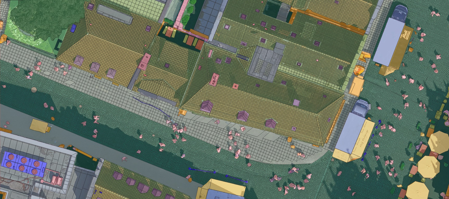
Unveiling Münster: A Paradigm Shift in Aerial Data with 2cm Resolution
Welcome to a new era of geospatial intelligence. This groundbreaking aerial imagery dataset, captured over the historic city of Münster, Germany, sets an unprecedented global standard with its stunning 2-centimeter ground resolution. Every image is a rich tapestry of urban and natural life, revealing details hitherto invisible in conventional satellite or aerial surveys—from the distinct textures of roof tiles and pavement cracks to the precise contours of individual vehicles and street fixtures.
This dataset is not merely a collection of images; it is a foundational layer for innovation, designed to empower a multitude of industries with actionable, pixel-level accuracy.
Revolutionizing Urban Planning & Smart City Development
For urban planners and municipal authorities, this dataset provides a digital twin of the city in exquisite detail. It enables precise analysis of land use, infrastructure density, and public space utilization. Planners can accurately map and monitor building footprints, assess the condition of roads and bridges, inventory green spaces, and plan new developments with a comprehensive understanding of the existing urban fabric. This level of detail is critical for designing sustainable, efficient, and resilient cities of the future.
Transforming Transportation and Autonomous Systems
The automotive and transportation sectors will find an invaluable resource for training and validating next-generation AI. The ultra-high resolution allows for the precise identification and classification of objects essential for autonomous driving algorithms, including cars, buses, bicycles, pedestrians, and even subtle road features like curb edges and street signs. This facilitates the development of safer and more reliable perception systems for self-driving cars and intelligent traffic management solutions.
Advancing Environmental Monitoring and Management
Environmental scientists and conservationists can leverage this data for granular ecological assessment. The ability to distinguish between grass, shrubs, forests, and bareland with extreme precision supports detailed vegetation health monitoring, urban heat island effect studies, and biodiversity mapping. It allows for the tracking of changes in natural landscapes over time with a level of accuracy that was previously unattainable.
Empowering Insurance and Risk Assessment
The insurance industry can revolutionize its risk modeling and claims processing. High-resolution imagery enables pre- and post-event damage assessment for individual properties, allowing for accurate evaluation of roof conditions, swimming pools, and other structural assets. This leads to more precise underwriting, faster claims settlement after natural disasters, and a deeper understanding of portfolio risk exposure.
Fueling the Future of AI and Computer Vision
This dataset serves as a benchmark for the academic and industrial AI communities. The fine-grained object classes—from roof-vent and curb-edge to awning and mashble—present a challenging and rich training ground for advanced machine learning models in semantic segmentation, instance segmentation, and object detection. It accelerates the development of robust computer vision models that can interpret complex real-world environments with human-like precision.
Optimizing Utility and Infrastructure Management
Utility companies can use this imagery for infrastructure planning and maintenance. The clear visibility of roof types, skylights, and vents aids in solar potential mapping, while the detailed view of streets assists in planning fiber-optic cable routes and managing other public utilities efficiently.
Dataset Features:
Ultra-High Resolution: 2 cm GSD (Ground Sampling Distance)
Comprehensive Object Classes: Includes both common and fine-grained urban elements
Ideal for Computer Vision Tasks: Such as semantic segmentation, object detection, and land use classification
Object Classes Included:
Infrastructure & Urban Elements:
Building, Road, Driveway, Pavement, Bridge, Sidewalk, Curb Edge
Parking, Swimming Pool, Street Light, Roof Types (Tiles, Concrete, Skylight, Opening, Vent, Fixture)
Sign Post, Awning, Marble Surfaces
Transportation:
Car, Bus, Bike
Natural & Outdoor Features:
Grass, Forest, Shrub, Bareland
Miscellaneous:
Person, Table, Chair, Unidentified Objects
Potential Applications:
Autonomous driving simulation
Urban planning and development
Environmental monitoring
AI model training and validation
Geographic Information Systems (GIS) analysis
Where every pixel tells a story. Explore the city of Münster, Germany, in breathtaking 2cm resolution—capturing life from the rooftops to the roadside. This is detail, redefined.
This dataset stands out for its granularity and diversity, capturing even the most subtle urban details—from roof fixtures and pavement edges to shrubbery and street signage. It represents a significant step forward in high-resolution aerial data collection and is designed to support cutting-edge research and innovation.
Unlocking Custom Solutions: Let’s Build the Future Together
The intricate details captured in this Münster dataset illustrate just a fraction of what is possible with today’s aerial imaging technology. Whether your organization requires similarly precise mapping for another city, specialized object detection classes tailored to your unique needs, or large-scale environmental monitoring, we are here to deliver. We invite government agencies, research institutions, and industry leaders to contact us to discuss custom project collaborations. Let’s transform the way you see and interact with the world—one centimeter at a time.
Contact us today to order a similar solution for your region or project.