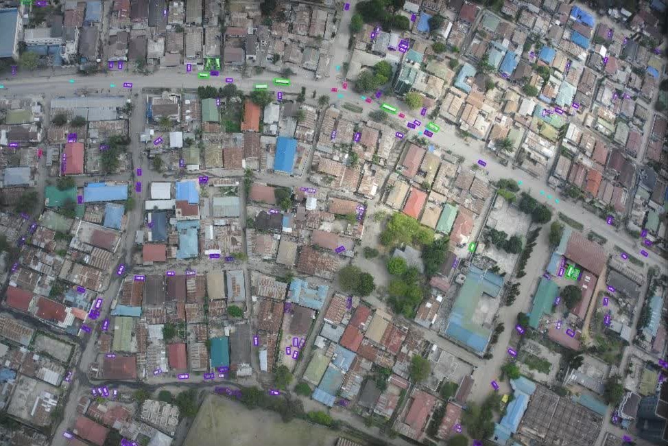
Vehicle Detection in Aerial Imagery – Africa (Multi‑Class with Attributes)
Region: Africa Imagery type: High‑resolution aerial images (low‑flying aircraft) Output: Bounding boxes with vehicle class and per‑object attributes
Project Overview
Nazru’s AI platform was deployed to detect and classify vehicles from high‑resolution aerial imagery collected over various African regions. Unlike satellite‑based projects (where only large/small classes were used), this project required fine‑grained classification and additional attributes to support local traffic monitoring, humanitarian logistics, and urban planning.
The Challenge
Aerial imagery over Africa presents unique difficulties:
Wide variety of vehicle types – from standard cars and trucks to motorcycles, minibuses (matatus/taxis), and agricultural vehicles.
Harsh lighting conditions – bright sunlight, deep shadows, and dust.
Informal roads and unpaved areas – vehicles may be parked in irregular patterns, making detection harder.
Occlusion – vehicles under trees, thatched roofs, or between dense buildings.
Class imbalance – many small vehicles (cars, motorcycles) and fewer large trucks.
The client required not just detection but also classification into meaningful categories and attributes such as occlusion, truncation, and confidence.
The Nazru Solution
Nazru’s platform used a lightweight aerial‑optimised detector (e.g., YOLOv8 or EfficientDet) trained on thousands of annotated aerial images from Africa. The model:
Detects vehicles as oriented or axis‑aligned bounding boxes.
Classifies each vehicle into one of several classes (example classes – to be confirmed by client):
car (standard passenger vehicle)
motorcycle (including scooters)
bus / minibus (public transport)
truck (heavy goods vehicle)
agricultural (tractor, combine)
other (e.g., construction vehicle, ambulance)
Assigns attributes per detection:
occluded (percentage 0–100)
truncated (True/False if cut by image edge)
uncertain (True/False for low‑confidence predictions)
orientation (angle or direction of the vehicle, if visible)
Outputs georeferenced bounding boxes in standard GIS formats.
Key Results & Benefits
High‑accuracy vehicle detection across diverse African landscapes (urban, rural, desert, forest).
Attributes support downstream tasks like occlusion handling and confidence‑based filtering.
Scalable to large aerial surveys (hundreds of square kilometres).
Useful for – road infrastructure planning, disaster response (counting vehicles in flooded areas), humanitarian aid (monitoring refugee camp traffic), and wildlife park vehicle tracking.
Key Technologies Used
Object detection (YOLOv8 / EfficientDet) with custom training on African aerial datasets.
Oriented bounding boxes (optional) for vehicles at arbitrary angles.
Attribute regression – occlusion percentage and orientation.
GIS integration – output as GeoJSON, Shapefile, or KML with WGS84 coordinates.
High‑resolution aerial image from [region, Africa]. Detected vehicles are shown as coloured bounding boxes.