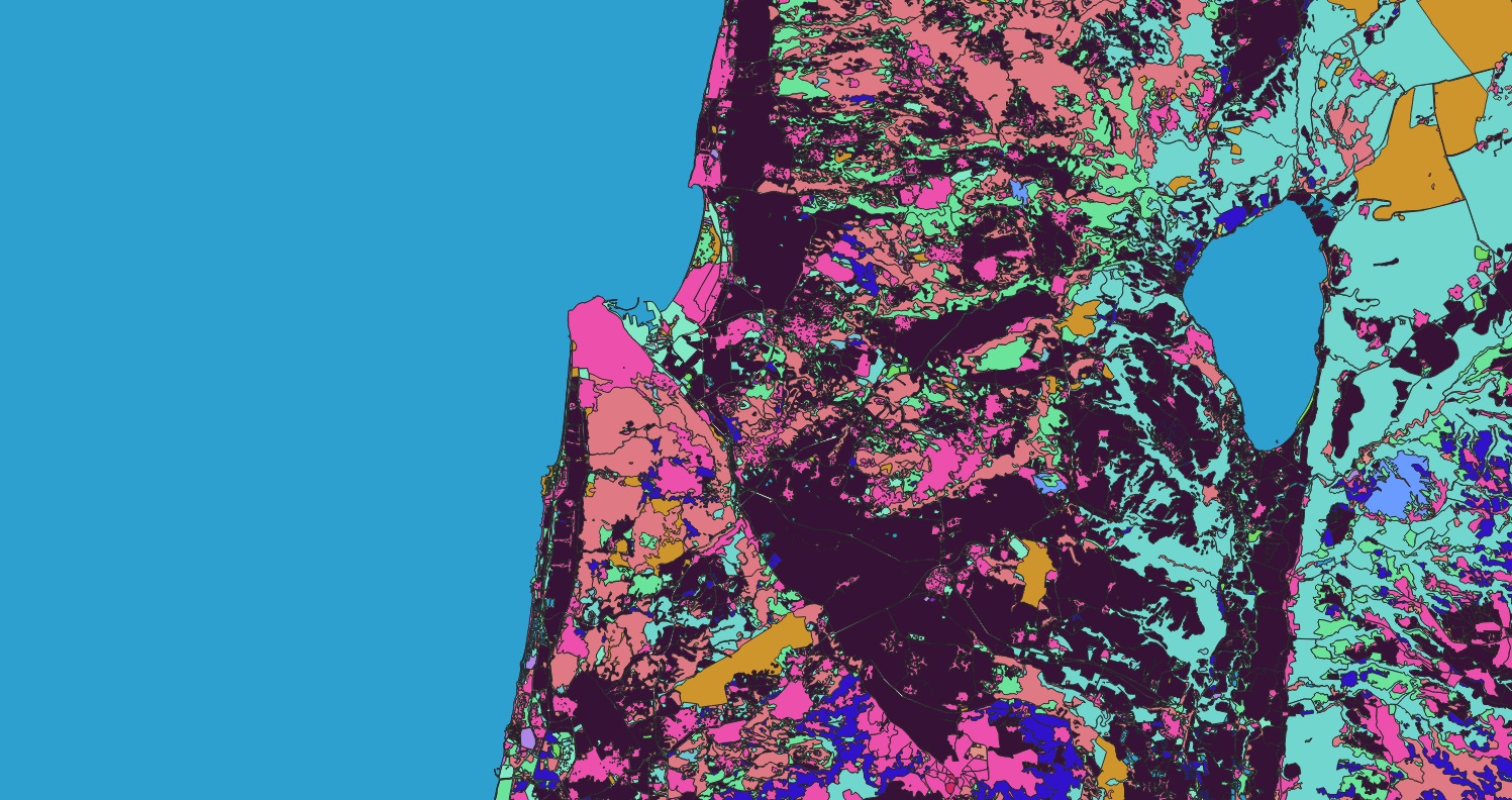
Dataset Overview
This dataset provides a high-resolution (10 meters) Land Use and Land Cover (LULC) classification map, segmenting geographic areas into 24 distinct and actionable classes. This precise cartographic resource is fundamental for spatial analysis, environmental monitoring, and strategic planning across a multitude of sectors. The classes form a comprehensive taxonomy of the terrestrial landscape.
Defined Land Cover Classes:
cemetery, commercial, farmland, farmyard, forest, grass, heath, industrial, meadow, military, nature_reserve, orchard, park, Road, quarry, recreation_ground, reservoir, residential, retail, riverbank, scrub, vineyard, water, wetland
Industry-Specific Applications & Relevance
The granularity of this 10m LULC data makes it a critical asset for informed decision-making in key industries. The applications are outlined below, with expanded detail for the most directly impacted sectors.
1. Civil Engineering & Urban Planning
(This industry has the most direct and frequent application of the dataset.)
This dataset is indispensable for the entire project lifecycle, from initial feasibility studies to long-term monitoring.
Site Selection & Feasibility Analysis: Identification of stable ground, avoiding protected or unsuitable areas (wetland, nature_reserve, quarry). Optimal routing for infrastructure like roads and pipelines to minimize impact on residential areas and farmland.
Impact Assessment & Mitigation: Quantifying the conversion of grass or forest to industrial or residential classes for environmental impact reports. Planning drainage and stormwater management based on riverbank and wetland locations.
Resource & Logistics Planning: Identifying nearby industrial zones for material sourcing or quarry locations. Assessing access through existing commercial and residential networks.
2. Municipal & State Government
(A primary user for public policy and asset management.)
This data serves as a foundational layer for smart city initiatives and effective public administration.
Zoning & Land Use Policy: Enforcing zoning regulations by monitoring unauthorized land use change, such as farmland conversion to residential or commercial. Planning for future urban expansion.
Tax Assessment & Fiscal Management: Maintaining accurate property tax rolls by tracking changes in land use (e.g., a meadow reclassified as retail).
Public Asset & Service Management: Managing public amenities like parks and recreation_grounds. Planning waste collection routes based on residential density. Identifying flood risks in riverbank zones.
3. Federal Government & National Agencies
(Applied for strategic, national-scale oversight and policy.)
The dataset provides a macro-level view for national security, resource management, and environmental stewardship.
National Resource Management: Monitoring national assets such as forest cover, water reserves (reservoir), and farmland to inform agricultural and water security policies.
Disaster Management & Homeland Security: Assessing damage from wildfires (impact on forest, heath, scrub), floods (inundation of residential and commercial areas), and other disasters. Monitoring activities in sensitive zones like military installations or border areas.
Environmental Compliance & Reporting: Tracking deforestation, wetland loss, and the effectiveness of nature_reserve protections to comply with national and international environmental commitments.
4. Insurance & Risk Modeling
(Critical for quantitative risk assessment and portfolio management.)
This LULC data is used to objectify risk exposure and streamline claims processing.
Geospatial Risk Assessment: Refining insurance premiums by quantifying exposure to perils. A residential property adjacent to forest or scrub has a higher wildfire risk; one in a riverbank zone has a higher flood risk. Commercial and industrial properties have distinct risk profiles.
Catastrophe Modeling & Response: Quickly delineating affected areas post-disaster to estimate portfolio exposure and prioritize claims adjustment efforts by identifying impacted residential, commercial, and industrial polygons.
5. Non-Governmental Organizations (NGOs) & Environmental Agencies
(Essential for advocacy, conservation, and monitoring.)
NGOs leverage this data for evidence-based conservation and to hold entities accountable.
Conservation & Habitat Monitoring: Tracking encroachment on nature_reserves, deforestation of forest areas, and degradation of wetland and heath ecosystems.
Agricultural & Sustainability Programs: Monitoring the expansion of farmland and orchards into natural ecosystems. Promoting sustainable land management practices.
Independent Auditing: Verifying corporate and government environmental claims, such as the effectiveness of set-aside land or the impact of a new quarry or industrial zone.
6. Telecommunications & Network Planning
(Used for strategic infrastructure deployment and optimization.)
The physical landscape directly influences network design and performance.
Network Infrastructure Siting: Selecting optimal locations for tower placement by analyzing terrain and obstacles (forest, orchard, industrial buildings) that impact signal propagation.
Demand Forecasting & Capacity Planning: Predicting service demand by analyzing the distribution of residential (evening usage) and commercial/industrial (daytime usage) areas to allocate network resources efficiently.
Right-of-Way Management: Planning fiber optic routes through corridors that minimize disruption, avoiding parks and dense residential areas where possible.