Skip to content

Road Line Classification & Quality Assessment (Case Study)

Location: Germany

Project Overview

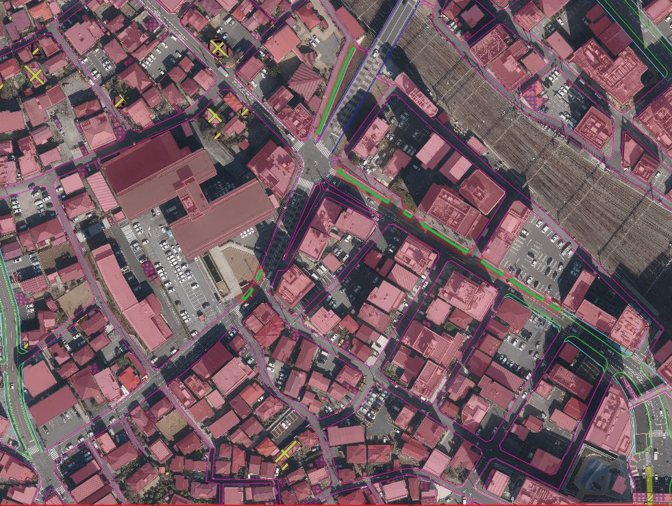
Nazru’s AI platform was deployed to classify road line types and pavement markings into detailed categories, assess occlusion (visibility), and evaluate physical quality. This project involved:

  • Distinguishing temporary yellow lines from permanent white lines

  • Detecting occlusion (lines covered by shadows, vehicles, debris, or wear)

  • Rating line quality into three levels: Bad – Medium – Good

  • Classifying line types (e.g., dashed_line, long_line, small_broken_line, etc.)

  • Classifying other pavement markings (crosswalk, arrows, stop_line, stop_sign, zones, international signs, words, etc.) based on the provided list

The Challenge

The client needed a comprehensive, automated inventory of all road markings, including both temporary and permanent lines, with precise classification of line patterns (dashed, long, small broken) and other symbols (arrows, signs, crosswalks, restricted zones). Additionally, they required occlusion detection and quality grading to prioritise maintenance. Traditional manual surveys were too slow, inconsistent, and expensive.

The Nazru Solution

Nazru’s platform addressed this challenge by integrating high‑resolution aerial and satellite imagery with proprietary AI models. Our algorithms automatically performed the following:

1. Line colour & permanence classification:

  • Temporary yellow lines

  • Permanent white lines

2. Occlusion detection:

  • Identifying segments where road markings are partially or fully covered

3. Quality assessment (per segment):

  • Bad: Faded, broken, or barely visible

  • Medium: Partially visible but still usable

  • Good: Clearly visible and intact

4. Line type classification:

  • dashed_line – standard dashed lane lines

  • long_line – longer dash patterns (e.g., warning lines)

  • small_broken_line – very short broken lines (e.g., turn pockets)

  • (Please add any other line classes you have, such as solid_line, double_solid, etc.)

5. Other pavement marking classification (complete list):

  • crosswalk

  • no_parking_zone

  • parking_zone

  • restricted_area

  • stop_line

  • stop_sign

  • straight_arrow

  • turn_left

  • turn_left_right

  • turn_left_straight_right

  • turn_right

  • turn_straight_left

  • turn_straight_right

  • other_international_signs

  • other_lane-markings_words

  • temporary_cancelled

  • the_rest_of_the_lane_markings

Key Results & Benefits

  • Complete, up‑to‑date digital inventory of all road markings with 20+ detailed classes

  • Clear separation of temporary (yellow) vs. permanent (white) lines for construction planning

  • Occlusion heatmaps showing where markings are hidden and need cleaning or re-evaluation

  • Quality‑graded maps (bad/medium/good) enabling data‑driven maintenance prioritisation

  • Fully automated workflow scalable to city‑wide or regional networks

Key Technologies Used

  • AI‑based semantic & instance segmentation

  • Colour classification (yellow vs. white)

  • Pattern recognition for dashed, long, and small broken lines

  • Occlusion detection using context‑aware models

  • Quality grading via line integrity and contrast analysis

A sample image from Munich for lane marking detection