The Application of Geospatial Data in Civil Engineering for Telecommunications Projects
Integration of Telecommunications in Civil Engineering Projects
Telecommunications and utility infrastructure serve as critical foundations for modern society, enabling essential services that support both economic development and community welfare. The deployment of broadband networks, 5G connectivity, and resilient power grids requires systematic planning, robust engineering, and ongoing maintenance to ensure uninterrupted service delivery.
These networks are implemented through diverse methodologies, including both subterranean and aerial installations, and are typically managed through partnerships between public authorities and private enterprises. Civil engineering firms provide vital expertise in this context, facilitating the design, implementation, and maintenance of infrastructure that aligns with public needs and technological progress.
Key considerations in the strategic development of these systems include:
Geospatial Analysis and Network Planning: Utilizing precise mapping and data analytics to optimize service coverage, capacity, and resource allocation.
Urban Integration and Future-Proofing: Ensuring seamless incorporation into existing cityscapes while anticipating future urban growth and technological demands.
Climate Adaptation and Disaster Resilience: Designing infrastructure to withstand extreme weather, seismic events, and other environmental challenges.
Regulatory and Environmental Compliance: Navigating legal frameworks and conducting impact assessments to ensure sustainable and compliant project execution.
This integrated, multidisciplinary approach guarantees that telecommunications and utility systems not only address immediate community requirements but also remain adaptable to forthcoming demographic and technological shifts.
A sample of road marking data extracted from geospatial imagery in Detroit, Michigan, USA.

At Nazru, we partner with civil engineering firms specializing in telecommunications and utility infrastructure by delivering highly accurate, AI-derived geospatial data. Our datasets are trusted by engineering firms working with municipal governments, telecommunications providers, and utility companies for diverse applications including network planning, expansion initiatives, and regulatory compliance.
Broadband Expansion
Despite the pervasive nature of digital connectivity, significant areas across Europe—particularly in rural and peripheral regions—still lack reliable broadband access. National governments and EU-funded programs actively work to bridge this digital divide by identifying underserved communities and expanding network infrastructure. Civil engineering firms are frequently engaged to provide technical expertise and project oversight for these critical initiatives.
While each project has unique requirements, broadband expansion typically involves civil engineers conducting detailed gap analyses to identify areas with limited connectivity and assess existing infrastructure capacity. This includes mapping broadband serviceable locations (BSLs), evaluating their proximity to existing network infrastructure, and determining feasibility for connection. In many cases, engineers develop innovative solutions to extend access to remote or topographically challenging locations, with involvement spanning from initial feasibility studies through to project implementation and monitoring.
5G Network Planning
Civil engineers are increasingly engaged by municipal authorities and telecommunications providers to support the strategic rollout of 5G networks across European urban centers. This requires comprehensive understanding of existing infrastructure and its impact on network performance, as well as assessment of community needs to determine appropriate infrastructure requirements.
For 5G planning projects, civil engineers typically analyze current mobile data usage patterns to determine capacity requirements across residential, commercial, and public spaces. Many incorporate socioeconomic projection data to ensure network infrastructure can support future community needs. Additionally, engineers evaluate how both natural and built environments affect signal propagation—addressing challenges such as the “urban canyon” effect where tall buildings, dense vegetation, or other structures cause signal interference. Civil engineers provide essential consulting and project management services throughout the 5G deployment lifecycle.
Project Permitting
Following initial analysis, most telecommunications and utility projects require permits from relevant local or national authorities. The permitting process is often extensive, requiring detailed documentation of project objectives, methodology, and potential impacts on existing infrastructure. Civil engineers typically lead this process, which can divert significant resources from other strategic project activities.
Permit applications generally require comprehensive documentation of the project area and potential impacts, including detailed maps and visualizations of proposed work. For aerial installations, reports must demonstrate impacts on land cover and structures; for underground work, engineers must specify how existing infrastructure will be affected and subsequently restored. For example, projects requiring road excavation must include detailed plans for restoring pavement markings and surface integrity upon completion.
Geospatial Data for Telecom Projects in Civil Engineering
Data and analytics form the foundation of all three telecommunications applications. When civil engineers collaborate with stakeholders on these projects, they require precise, up-to-date understanding of both natural and built environments and their potential impact on project objectives. This knowledge is essential for infrastructure assessment, improvement recommendations, and effective project management.
Geospatial data is particularly crucial in this context. By leveraging high-precision maps that accurately represent real-world conditions, civil engineers can perform sophisticated analytics to guide telecommunications and utility infrastructure strategies. This approach eliminates the need for resource-intensive field surveys and manual digitization. While various geospatial datasets support telecommunications projects, the four most critical are building footprints, 3D building models, road markings, and land cover classification.
Building footprints
A sample of building footprint data in Kikuchi, Japan.

One of the most critical geospatial datasets for telecommunications projects in civil engineering is building footprint data. Building footprints are essential for accurately identifying Broadband Serviceable Locations (BSLs), particularly when enhanced with rooftop-level geocoding.
European regulatory bodies, such as the national regulatory authorities aligned with the Body of European Regulators for Electronic Communications (BEREC), typically require a clear distinction between permanent, serviceable structures and non-qualifying outbuildings. Structures such as garden sheds, standalone garages, or small agricultural buildings are often not classified as individual BSLs, even if they are situated on a larger, serviceable property. In such cases, the entire property is typically classified as a single BSL, encompassing all its structures.
While many European countries maintain national address and building registries, civil engineers frequently supplement these with third-party data to ensure they are working with the most current and comprehensive dataset available. The pace of urban development and land use change means that official registries can quickly become outdated.
For instance, a recent analysis in a predominantly rural region of a European member state found that over 15% of existing buildings were missing from the official national database. By utilizing Nazru’s AI-generated building footprint data, the regional authority was able to create a complete and accurate map of all structures. This comprehensive dataset was instrumental in a successful application for significant funding from the EU’s Connectivity Broadband Fund, securing hundreds of millions of euros to expand broadband access to underserved communities.
3D Buildings
For advanced network planning, particularly for 5G and future-generation wireless technologies, 3D building models are indispensable. While 2D footprints show a building’s location and footprint, 3D data provides critical volumetric information, including:
Building Height and Roof Structure: Essential for determining optimal placement for radio equipment, line-of-sight analysis, and signal propagation modeling.
Facade and Morphology Details: Allows engineers to assess signal reflection, penetration, and potential “urban canyon” effects in dense city centers.
Accurate Volume and Massing: Critical for environmental impact studies, visual simulations, and complying with local planning regulations for new mast or antenna installations.
By leveraging Nazru’s 3D building data, derived from aerial and satellite imagery, civil engineers can move beyond simple coverage maps to create sophisticated, predictive network models. This enables them to design more resilient and efficient telecommunications infrastructure, ensuring robust connectivity even in the most complex urban environments.
A sample of 3D building data in in ……
3D Building Data for Advanced Network Planning
Height-attributed building data is fundamental for sophisticated telecommunications planning. 3D building models provide the critical volumetric detail needed for civil engineers to accurately simulate radio signal propagation and predict how structural heights will impact network performance. While 3D buildings are the primary source for this analysis, engineers frequently augment their models with 3D data for bridges and vegetation to create comprehensive signal performance analytics that account for all major obstacles in the environment.
Beyond signal propagation modeling, 3D building data enables strategic infrastructure siting. Structures of specific heights distributed throughout a project area can be identified as optimal locations for antennas or signal repeaters, allowing engineers to design networks that maximize coverage and capacity based on a community’s unique geographical layout and service requirements.
Road Markings & Transportation Infrastructure
Road markings and transportation data provide crucial context for both aerial and underground infrastructure deployment. For civil engineers working on telecommunications projects, this data enables:
Permitting and Installation Planning: Identifying optimal routing for fiber optic cables and other infrastructure within public rights-of-way
Utility Corridor Management: Mapping existing underground utilities to avoid conflicts during new installations
Traffic Flow Analysis: Assessing potential disruptions during deployment and maintenance operations
Safety Compliance: Ensuring installations meet all regulatory requirements for visibility and accessibility
By integrating detailed road marking data with other geospatial layers, civil engineers can optimize network rollout while minimizing community disruption and ensuring compliance with municipal regulations. This comprehensive approach is particularly valuable for 5G small cell deployment and fiber-to-the-premises projects requiring extensive work in public thoroughfares.
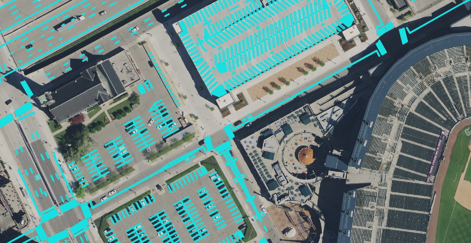
A sample of road marking data extracted from geospatial imagery in Detroit, Michigan, USA.
Road Marking Data for Efficient Infrastructure Permitting
Road marking data—also referred to as paint striping data—provides a precise geospatial representation of painted symbols and lines on roadways. This includes detailed information about double yellow lines, dashed lane dividers, shoulder markings, turn lanes, crosswalks, bicycle symbols, and other essential visual guidance systems.
The primary application for this highly detailed data is in streamlining permitting workflows for civil engineers managing underground utility and telecommunications projects. For decades, the standard practice required engineers to manually digitize existing road markings to document how proposed excavation work would impact existing infrastructure and specify restoration requirements post-project completion.
The intricate nature of road marking systems, combined with the painstaking effort of manual digitization, traditionally created significant bottlenecks in the permitting process. This often resulted in:
Extended project timelines due to protracted approval cycles
Reduced engineering productivity as valuable billable hours were consumed by manual cartographic tasks
Delayed infrastructure improvements for communities
Transformation Through Automated Mapping
Recent breakthroughs in AI-powered feature extraction have revolutionized this workflow. Advanced automated mapping systems can now rapidly detect and digitize road markings from high-resolution aerial and street-level imagery with precision matching manual methods. This technological advancement delivers substantial benefits:
Accelerated Permitting: Permitting packages can be prepared in days rather than weeks
Enhanced Accuracy: Automated systems provide consistent, comprehensive documentation of existing conditions
Resource Optimization: Engineering staff can focus on higher-value design and analysis tasks
Cost Reduction: Significant savings in both labor costs and project delays
This transformation exemplifies how Nazru’s geospatial solutions are modernizing critical infrastructure workflows, enabling civil engineers to navigate regulatory requirements more efficiently while delivering projects that better serve community needs.
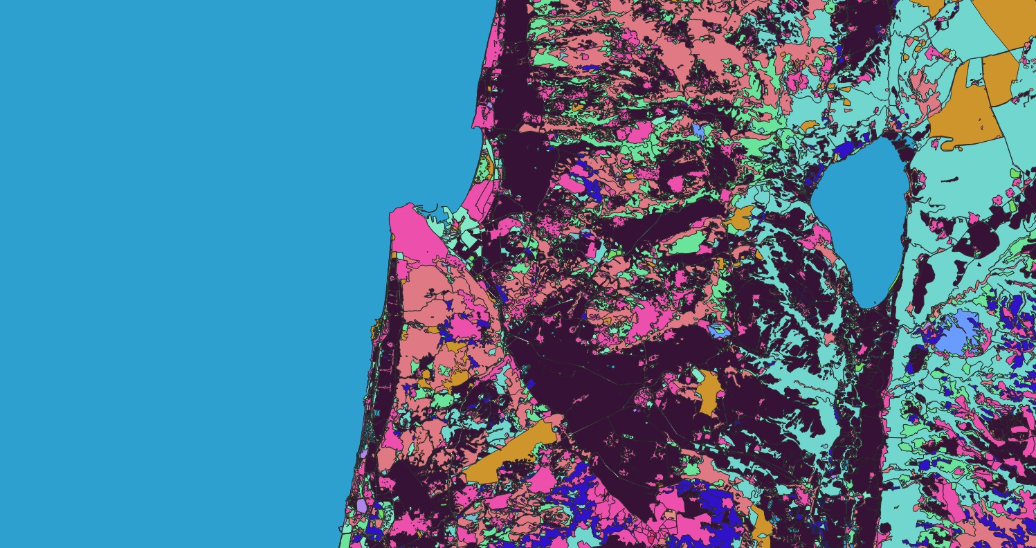
Land cover
A sample of land cover data in Geneve, swiss.


Land Cover Data for Strategic Infrastructure Planning
In an era of rapid land use change, land cover data has become an indispensable analytical tool for civil engineers working on telecommunications and utility infrastructure projects. By categorizing earth surfaces into distinct classes—such as impervious surfaces, vegetation, water bodies, and bare soil—this data provides critical environmental context that informs every stage of project development, from initial planning to risk assessment and regulatory compliance.
Key Applications in Telecommunications & Utility Projects:
Climate Risk Assessment: Land cover data enables engineers to evaluate infrastructure vulnerability to natural hazards. For example, analyzing proximity to water bodies helps assess flood risk to telecom equipment, while vegetation coverage can indicate potential wildfire zones. This proactive analysis supports the development of climate-resilient infrastructure designs.
Optimal Infrastructure Siting: By understanding land cover patterns, engineers can identify optimal locations for new utility infrastructure that minimize environmental impact while maximizing operational efficiency. This is particularly valuable for avoiding geologically unstable areas, protecting sensitive ecosystems, and ensuring long-term infrastructure performance.
Advanced Network Planning: Beyond basic coverage analysis, land cover data enhances signal propagation modeling for 5G and other wireless technologies. When combined with 3D features like tree canopies and building heights, it helps engineers predict and address signal obstruction in complex environments, from dense urban centers to vegetated rural areas.
Environmental Compliance & Sustainability: Land cover data supports environmental impact assessments by documenting pre-existing conditions and helping engineers design projects that minimize disruption to natural habitats. This is increasingly important for meeting EU environmental directives and securing project approvals.
The integration of comprehensive land cover data, particularly when enhanced with 3D attributes, provides civil engineers with a powerful foundation for designing telecommunications and utility networks that are not only technically efficient but also environmentally responsible and resilient to future climate challenges.
Scaling Civil Engineering Telecom Projects with AI
Geospatial data forms the critical foundation for civil engineers working on telecommunications and utility infrastructure projects across both public and private sectors. However, conventional approaches to data creation have traditionally forced engineering teams to divert valuable billable hours toward manual digitization tasks rather than higher-value strategic analysis and consultation—the core expertise that delivers maximum client value.
The efficiency gap between traditional and AI-powered methods is substantial. For example, Nazru generated a comprehensive 3D land cover dataset for a major European metropolitan area in just two weeks—a task that manual methods would have stretched over eight months, dramatically accelerating the project timeline and enabling faster decision-making.
Transforming Engineering Workflows with AI
Modern artificial intelligence now enables civil engineers to rapidly map complex features across project areas within weeks while maintaining the precision standards of certified GIS professionals. This accelerated process delivers three key advantages:
Expanded Project Capacity: Access to timely, accurate geospatial data allows engineering firms to take on more client projects without increasing overhead for manual data creation.
Strategic Focus: Engineers can redirect billable hours from routine digitization to high-value analysis, design optimization, and client advisory services.
Accelerated Delivery: Project timelines can be compressed from months to weeks, enabling faster infrastructure deployment and community benefits.
Nazru’s Partnership Approach
Nazru collaborates closely with civil engineering firms to streamline geospatial data creation while maintaining rigorous quality standards. Our AI-powered mapping systems, developed by geomatics and engineering specialists, extract precise vector features from geospatial imagery with human-level accuracy. All data undergoes comprehensive quality assurance by our expert team before delivery, ensuring it meets the precise specifications required for engineering applications.
This efficient workflow enables civil engineers to acquire customized, project-ready geospatial data within weeks rather than months, transforming how they approach telecommunications and utility infrastructure projects.
To learn how Nazru can help scale your geospatial data capabilities for telecommunications and civil engineering projects, contact our team of experts.