Top Applications for Building Footprint Data
The Critical Role of Building Footprint Data in Modern Decision-Making
Building footprints are polygonal representations of physical building structures. These vectors are often enriched with contextual metadata, providing details on a building’s purpose, its relationship to nearby locations, and its precise address. With diverse applications across numerous industries—from wildfire threat analysis and flood vulnerability assessment to broadband network planning and insurance risk evaluation—building footprints have become a powerful, indispensable tool for informed decision-making.
This blog will explore some of the most innovative ways organizations are leveraging Nazru’s high-precision building footprint data.
Challenges in Accessing Accurate Building Footprint Data
Despite its significant value, organizations have historically faced considerable challenges in sourcing comprehensive, accurate, and up-to-date building footprint data. The primary methods of acquisition each present distinct drawbacks:
Manual Digitization: While thorough, creating data manually is incredibly time-consuming and cost-prohibitive, especially at scale. This process often results in data that is outdated by the time of completion, severely hindering its analytical value. Furthermore, using outdated or low-resolution imagery for digitization can lead to inaccurate and incomplete representations of the current landscape.
Open Source Datasets: Relying on existing third-party open source datasets is a common alternative. However, these datasets frequently lack the necessary completeness, consistency, and accuracy required for enterprise-level applications.
Commercial Data Providers: Purchasing data from a vendor is another option. However, creating and maintaining highly accurate building footprints at scale demands advanced artificial intelligence (AI) technology and access to high-quality imagery. Many vendors lack the technological capabilities or imagery partnerships to guarantee data accuracy. While methodologies vary, no provider offers building footprint data as comprehensive, accurate, and current as Nazru’s.
How Nazru is Redefining Building Footprint Data at Scale
Nazru addresses these challenges directly through its technologically advanced, robust mapping and geocoding pipeline.
1. AI-Powered Mapping for Unmatched Accuracy
Nazru’s advanced AI-based mapping systems automatically detect, extract, and update geospatial features from high-resolution imagery. This results in a complete building footprint collection for the entire United States, delivered with contractually guaranteed accuracy specifications of 95% or higher.
2. Sophisticated Building-Based Geocoding
Nazru’s Building-Based Geocoding pairs this comprehensive building footprint dataset with best-in-class address data. Our proprietary geocoding engine, designed to process vast amounts of geospatial information, utilizes a unique machine learning-based parsing system to accurately match each address to its corresponding building. This process yields the most comprehensive rooftop-level geocoding coverage nationwide.
3. Commitment to Continuous Updates
To ensure data currency, Nazru leverages partnerships with leading geospatial imagery providers to source fresh, high-resolution imagery of the US annually. These updated building footprints are then systematically enhanced with the most current address data available.
Top Applications for Building Footprint Data
Nazru has empowered numerous organizations—from government agencies and insurance providers to telecommunications companies and civil engineering firms—by managing the complex tasks of data sourcing and maintenance. Our accurate, up-to-date database enables these organizations to scale their analysis and drive innovation.
The following are some of the most impactful use cases for high-precision building footprint data.
1. Insurance Property Risk Assessment
In property insurance underwriting, accurately pricing a policy depends on assessing the risk to a specific structure, which includes measuring its proximity to high-risk areas such as flood zones. While latitude and longitude points can approximate a property’s location, they fail to capture the detailed spatial relationship between the building itself and adjacent hazards.
For instance, a policy priced using only a point data derived from a parcel centroid may miscalculate the building’s true distance to a flood zone or wildfire risk area. Without the precise spatial context provided by a building footprint, an underwriter may inadvertently underprice the policy. This exposes the insurer to significant financial risk in the event of property damage, as the true exposure was not accurately reflected in the premium.
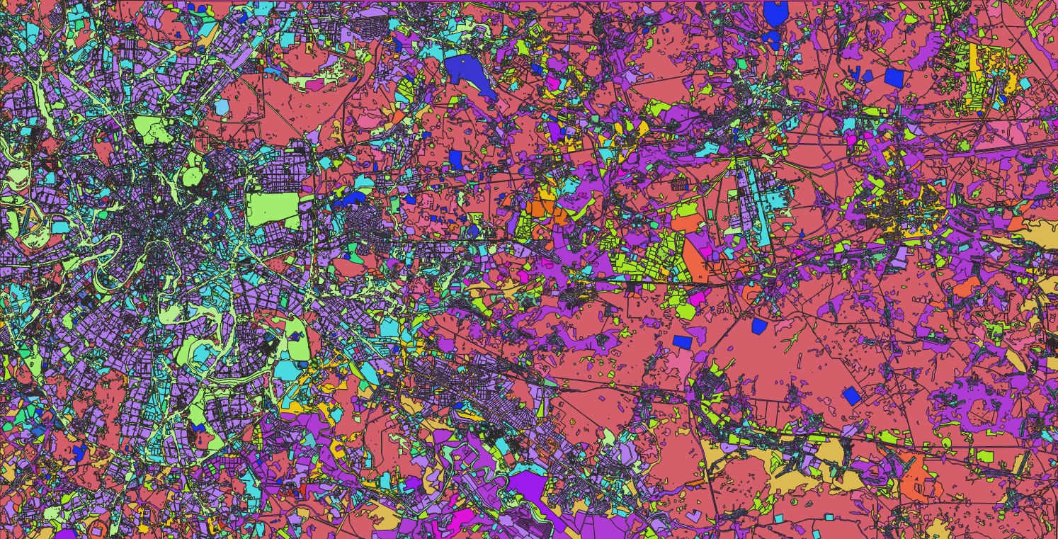
A sample of Nazru’s AI-powered Building-Based Geocoding data, derived from high-resolution imagery in Leverkusen, Germany.


2. Facilitating Infrastructure Planning and Development
Accurate building footprint data plays a pivotal role in critical infrastructure expansion projects worldwide. This data is indispensable for planning the deployment of essential services such as high-speed internet, electricity, and potable water to unserved and underserved communities.
Numerous national governments and international bodies have established major grant programs to bridge the digital divide and upgrade essential infrastructure. Success in securing such funding is often contingent upon submitting a precise and current map of all serviceable locations. A fundamental challenge for many regions is the lack of a unified, complete, and accurate geospatial database of buildings and their associated addresses.
The Nazru Solution: Establishing a Precise Foundation for Planning
In response to this challenge, Nazru provides highly accurate, scalable, and current building footprint data, empowering governments and organizations to strengthen their eligibility for funding and ensure the effective execution of projects.
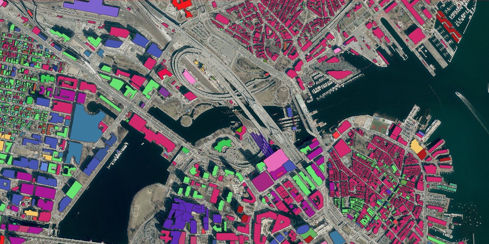
A sample of building footprints extracted by Nazru’s AI-based mapping systems in kikuchi, Japan.

3. Emergency Response & Public Safety
Beyond infrastructure development, highly accurate building footprint data has proven critical for enhancing public safety and emergency response capabilities worldwide. A primary challenge in many regions is the lack of a complete and standardized addressing system, which can severely delay emergency services.
The Nazru Solution: Building a Foundation for Public Safety
Nazru’s building footprint data provides the foundational layer for modernizing public safety infrastructure. By offering a precise, location-based inventory of every structure, governments and emergency response agencies can identify critical gaps in physical address data. This initiative is crucial for advocating and securing continued funding for comprehensive address data development programs.
The application of this data is instrumental in the transition to Next-Generation 911 (NG911) systems, which rely on precise geographic information to route emergency calls and resources effectively. By knowing the exact location and footprint of every building, responders can decrease critical response times, improve situational awareness, and ultimately save lives.
4. Wildfire Threat Assessment & Mitigation
Globally, the frequency and intensity of wildfires are increasing, posing a devastating and growing risk to communities and ecosystems. In this context, precise building footprint data is indispensable for modern wildfire risk assessment and mitigation strategies.
Understanding the exact location, size, and spatial relationship of structures to fire-prone wildland-urban interfaces (WUI) is critical. Nazru’s building footprint data enables governments and disaster management agencies to accurately map this exposure. This intelligence facilitates targeted prevention and preparedness measures, such as:
Identifying high-risk structures for prioritized evacuation planning.
Designing strategic firebreaks and other defensive infrastructure.
Implementing community-scale fuel management programs.
Application in Risk Modeling and Insurance
From a financial risk perspective, Nazru’s data provides a critical layer for portfolio analysis. Insurers and reinsurers use it to precisely identify properties within or adjacent to high-risk zones, enabling more accurate risk selection and policy pricing. Furthermore, the ability to track changes in building footprints over time is vital for post-disaster response, allowing for rapid assessment of property damage and the continuous refinement of catastrophe models to better reflect evolving risks.
5. Flood Risk and Coastal Hazard Management
Flooding represents one of the most pervasive and destructive natural hazards globally, threatening communities and infrastructure in coastal and inland regions alike. As climate change increases the frequency and severity of flood events, the ability to accurately assess and mitigate this risk is paramount.
Nazru’s high-precision building footprint data serves as a foundational element in flood risk analysis and coastal hazard management. By providing detailed information on the precise location and spatial extent of structures, this data enables a thorough analysis of a community’s potential exposure to flood events.
Key Applications for Resilience Planning:
Vulnerability Assessment: Urban planners and disaster management agencies integrate Nazru’s building footprints with flood zone models to identify and assess the vulnerability of specific residential, commercial, and critical infrastructure.
Mitigation Prioritization: This analysis allows for the strategic prioritization of protective investments, such as the construction of levees, sea walls, or enhanced drainage systems, in the areas where they are needed most.
Damage Projection and Recovery: By understanding the number and type of structures within a floodplain, authorities can better project potential damage, plan for efficient emergency response, and streamline recovery efforts.
This data-driven approach is essential for developing robust climate adaptation strategies, enhancing community resilience, and safeguarding economic assets against the growing threat of floods.
A comparative analysis of building footprints extracted by Nazru’s AI-based mapping systems, showing the devastating impact of floods in the city of Nürburgring, Germany.
Flood Damage


6. Stormwater Management and Sustainable Urban Planning
Municipal governments worldwide utilize mechanisms such as Stormwater Utility Fees (SUFs) to fund the creation, improvement, and maintenance of critical stormwater infrastructure. This is a vital task for managing urban runoff, reducing pollution, and enhancing climate resilience. High-precision building footprint data is instrumental in calculating these fees accurately and equitably.
The Role of Nazru’s Geospatial Data
The accurate assessment of SUFs relies on a detailed understanding of impervious surfaces, such as rooftops and pavements, which contribute significantly to stormwater runoff. Nazru’s AI-based mapping systems excel at rapidly extracting and classifying these surfaces, including building footprints, at a city-wide or national scale.
Key Benefits for Municipalities:
Efficiency and Revenue Accuracy: By automating the mapping process, Nazru enables municipalities to move away from slow, manual digitization. This ensures fee structures are based on current data, preventing revenue loss from outdated assessments and ensuring all properties are billed fairly according to their actual impact.
Continuous Monitoring: Nazru’s commitment to providing regularly updated land cover data allows cities to monitor urban development and changes in impervious surfaces over time. This supports dynamic SUF assessment and proactive infrastructure planning.
Informed Infrastructure Investment: The data provides a clear and accurate basis for identifying areas with the highest runoff, enabling municipalities to prioritize infrastructure investments where they are most needed to build resilient and sustainable urban environments.
A sample of the impervious surface data, including building footprints, produced by Nazru AI for the City of in Linz, Austria.


7. Property Tax Assessment and Cadastral Management
Tax assessment offices globally are responsible for maintaining accurate and current property records—a complex challenge given that property values can be influenced by even minor physical changes. To address this, assessors are increasingly turning to advanced geospatial data to modernize, streamline, and bring greater objectivity to the appraisal process.
Enhancing Valuation Accuracy with Geospatial Intelligence
In property valuation, assessors must consider not only the primary structure but also its context, including proximity to surrounding features such as other homes, parks, major roads, or schools. Nazru’s high-precision building footprint data provides a critical foundation, offering definitive insights into the precise location and dimensions of all structures.
Comprehensive Feature Extraction for a Holistic View
Beyond building footprints, Nazru’s advanced AI systems can extract a comprehensive inventory of both natural and man-made features from high-resolution imagery. This includes secondary structures such as garages, swimming pools, decks, and patios, as well as the extent of greenspaces. This detailed dataset provides a complete and verifiable view of property characteristics that influence value, enabling more efficient and accurate desktop-based appraisals.
Ensuring Compliance and Data Integrity
A key challenge for tax authorities is identifying unpermitted construction. Nazru’s automated change detection capabilities systematically monitor for new structures or additions to existing ones. This allows assessment offices to maintain more complete and accurate property records, ensuring tax rolls are up-to-date and that all improvements are properly assessed, thereby safeguarding municipal revenue.
8. Population Estimation and Urban Planning
High-precision building footprint data from Nazru provides governments, researchers, and international organizations with a powerful methodology for deriving insights into population distribution and growth patterns. This approach is particularly vital in regions where traditional census data is infrequent, unreliable, or difficult to collect.
Mapping Populations with Geospatial Intelligence
By analyzing the density, type, and square footage of buildings within a specific area, reliable estimates of population distribution can be modeled. This technique is exceptionally valuable for identifying and mapping households in remote, rural, or rapidly developing informal settlements that are often underrepresented in official statistics.
Enabling Dynamic Forecasting and Strategic Planning
Nazru’s capability to track changes in building footprints over time—monitoring new construction, demolitions, and expansions—dramatically enhances the accuracy of dynamic population forecasting. This data is critical for:
Identifying and quantifying urbanization trends and internal migration patterns.
Refining annual population estimates between official census cycles.
Informing long-term, data-driven strategic planning for essential public services, including transportation networks, schools, and healthcare facilities, ensuring that infrastructure development keeps pace with population needs.
9. Urban Heat Island Mitigation and Climate-Resilient Planning
Building footprint data from Nazru is a critical resource for analyzing and mitigating the urban heat island (UHI) effect, a phenomenon where metropolitan areas experience markedly higher temperatures than their rural surroundings due to human activities and altered land surfaces. The prevalence of buildings and impervious infrastructure, which absorb and reradiate solar energy more effectively than natural landscapes, makes dense urban centers particularly susceptible.
The consequences of elevated urban temperatures are far-reaching, including increased risks of heat-related illnesses, degraded air quality, heightened energy demand for cooling, and potential impacts on water quality. Consequently, UHI mitigation has become an essential objective of sustainable urban planning and climate adaptation strategies.
Data-Driven Mitigation and Planning
Nazru’s high-precision geospatial data enables a proactive and targeted approach to heat mitigation. By analyzing the precise spatial distribution, density, and height of buildings in conjunction with other impervious surfaces, urban planners and environmental scientists can:
Identify Vulnerability Hotspots: Accurately pinpoint neighborhoods and districts most vulnerable to extreme heat accumulation.
Optimize Mitigation Strategies: Determine the most effective locations for interventions such as the installation of green roofs, the expansion of urban green spaces and parks, and the implementation of cool or reflective paving materials.
Model Intervention Efficacy: Simulate the potential cooling benefits of various mitigation strategies before implementation, ensuring the most efficient use of public resources for enhancing urban resilience and public health.
10. Land Use Planning and Utility Management
In an era of rapid population growth and accelerated urbanization, proactive and data-informed planning is fundamental to ensuring sustainable development and the long-term well-being of urban and peri-urban communities. Nazru’s building footprint data serves as a critical tool for planners and engineers, providing the foundational intelligence required to guide this growth effectively.
Strategic Planning and Infrastructure Forecasting
By delivering accurate, current, and comprehensive information on the location, type, and density of structures, Nazru’s data enables a forward-looking approach to urban management. This intelligence is directly applied to:
Demand Forecasting: Accurately projecting future demand for essential utilities—including electricity, water, sewage, and gas—by analyzing development patterns and building occupancy potential.
Infrastructure Gap Analysis: Identifying areas where existing utility networks are approaching capacity or are underserved, allowing for strategic prioritization of capital investments.
Master Planning: Informing comprehensive land use plans and zoning decisions to ensure that new developments are supported by the necessary infrastructure from the outset.
This data-driven methodology is indispensable for managing growth in rapidly expanding regions. It ensures that critical infrastructure development keeps pace with—or even anticipates—community needs, thereby preventing service shortfalls and laying the groundwork for resilient and sustainable urban ecosystems.
Transform Decision-Making with Nazru’s Building Footprints
With Nazru, the challenge of mapping the built environment at a global scale is effectively solved. Our advanced, AI-powered mapping solutions deliver the most comprehensive, accurate, and up-to-date building footprint data available, providing organizations in every sector with a single source of truth for strategic, data-driven decision-making.
To discover how Nazru’s high-precision geospatial data can empower your projects and enhance your operational resilience, please contact our team of experts.