Transforming Next-Generation Emergency Response Systems with AI-Powered Geospatial Data
The Critical Need for Modernized Emergency Infrastructure
Across Europe, there is growing recognition of the urgent need to modernize emergency response infrastructure to meet the demands of today’s mobile society. While multiple components are essential for an effective public safety ecosystem, accurate and reliable geospatial data stands as the fundamental foundation. Precise location intelligence, particularly correct address points and building information, is crucial for emergency services and Public Safety Answering Points (PSAPs) to respond to emergencies with maximum speed and efficiency.
At Nazru, we leverage advanced artificial intelligence to extract critical features from high-resolution imagery, creating high-definition vector maps that are transforming emergency response capabilities across Europe. Our solutions, including Building-Based Geocoding, meet the essential requirements of comprehensiveness, accuracy, and reliability for Next-Generation 112 (NG112) systems.
The Shift to Digital Emergency Response Systems
The transition to NG112 systems represents a fundamental evolution from legacy analog technologies to digital, Internet Protocol (IP)-based infrastructure. This transformation involves multiple interconnected systems and factors, including:
Advanced network capabilities
Modern call handling systems
Streamlined operational processes
Robust geographic information systems (GIS) featuring:
Structure address points
Road centerlines
Emergency service boundaries
Jurisdictional boundaries
Despite the clear benefits, many European PSAPs face significant challenges in implementing these upgrades, primarily due to funding constraints and the complexity of maintaining accurate spatial data across multiple jurisdictions.
The Essential Foundation: Accurate, Comprehensive GIS Data
A reliable GIS database enables emergency responders and PSAP personnel to quickly identify dispatchable locations, significantly reducing response times and ultimately saving lives. The success of NG112 systems depends fundamentally on the availability of robust, well-maintained geospatial data.
For PSAPs and Emergency Communication Centers, an ideal GIS database must demonstrate:
Comprehensive Coverage: Complete data across all urban and rural areas with high positional accuracy
Precision: Accurate address data, building footprints, and attributes to ensure efficient emergency routing
Timeliness: Regular updates to reflect the constantly evolving built environment
Accessibility: Affordable solutions that enable all communities to benefit from modern emergency response capabilities
Nazru’s AI-Powered Geospatial Solution
Nazru’s HD mapping technology creates a digital representation of the physical world, providing unique insights at scale. Since our founding, our maps have served as accurate foundational data for numerous government and commercial applications across more than 30 countries worldwide.
Our Building-Based Geocoding Solution offers Europe’s most complete building footprint collection integrated with premium address data. By leveraging pan-European satellite and aerial imagery through our proprietary AI systems, we’ve created an off-the-shelf solution that enhances GIS databases for any PSAP or emergency communication center.
Key advantages of Nazru’s solution:
Comprehensive: Complete building footprint coverage across European urban and rural areas
Accurate: Advanced machine learning systems that precisely match address points to corresponding structures
Current: Regular update cycles ensuring data reflects the latest developments
Accessible: Cost-effective pricing models that make advanced geospatial intelligence available to communities of all sizes
This represents a transformative opportunity for municipalities and regions with limited resources to implement and maintain the sophisticated GIS databases required for modern emergency response systems.
By providing reliable, affordable, and up-to-date geospatial intelligence, Nazru is helping to build a safer, more responsive emergency infrastructure across Europe—ensuring that when seconds count, emergency services have the accurate location data they need to save lives and protect property.
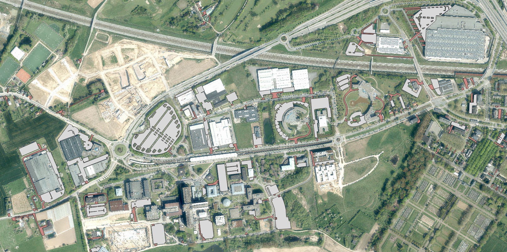
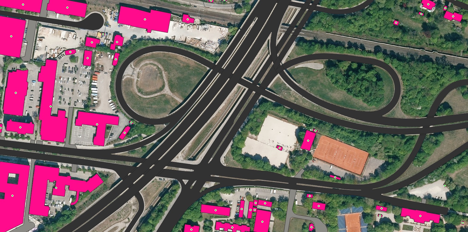
Sample Ecopia HD Map over Munich, Germany highlighting Building-Based Geocoding, Roads and Driveways


AI-Powered Geospatial Solutions for Next-Generation Emergency Response Across Europe
Nazru’s AI-driven, precise, and continuously updated geospatial data is transforming the capabilities of Public Safety Answering Points (PSAPs) and Emergency Communication Centers (ECCs) throughout Europe as they transition to Next-Generation 112 (NG112) systems. Through our collaborations with emergency service agencies and PSAP coordinators across the continent, we have witnessed significant recognition of the value our readily available GIS data brings to first responders and the communities they serve.
We are continuously expanding our partnerships with public safety stakeholders across European member states, focusing on enhancing and adapting our products to meet their evolving operational requirements. Our commitment extends beyond data delivery to ensuring our solutions integrate seamlessly with existing emergency response infrastructure while meeting the specific regulatory requirements of different European jurisdictions.
Proven Impact Across European Emergency Services:
Enhanced Location Accuracy: Precision-mapped building footprints and address points that reduce emergency response times
Cross-Border Compatibility: Standardized data formats that support international emergency response coordination
Cost-Effective Implementation: Affordable solutions that enable even under-resourced communities to benefit from advanced geospatial intelligence
Regular Updates: Continuous data maintenance that keeps pace with Europe’s rapidly changing built environment
For information on how Nazru can empower your local emergency response services with reliable, AI-powered geospatial data, please contact our public safety solutions team. We offer customized demonstrations and pilot programs tailored to your specific operational requirements and jurisdictional needs.
Together, we can build a safer, more responsive emergency infrastructure that serves all European communities with the efficiency and precision that modern technology enables.