Skip to content

Transportation Mapping Applications and Where to Acquire the Necessary Data

What is Transportation Mapping?

Transportation mapping is a widely utilized application of Geographic Information Systems (GIS) and geospatial data. Globally, transportation networks facilitate the movement of people, goods, information, and other resources to their required destinations. These networks consist of diverse transportation infrastructures, including roads, bicycle lanes, pedestrian walkways, railways, and similar components. Together, these elements form an integrated network designed to connect individuals and locations efficiently. Urban and regional planning departments continually work to improve and optimize these networks to better serve their communities.

As communities develop over time, their transportation demands and corresponding networks also evolve. For instance, population growth may necessitate the expansion of sidewalks to accommodate increasing pedestrian traffic. Conversely, a shift away from vehicular travel toward greater reliance on rail transit may require enhanced rail capacity. Transportation networks are inherently dynamic, continuously adapting to meet the changing needs of the populations they serve.

Accurate mapping of these evolving systems is essential for effective planning and management. Numerous geospatial solutions exist to support navigation and optimize transportation efficiency, ensuring seamless connectivity between destinations.

Transportation Planning Data Use Cases

Transportation maps do more than guide individuals to their destinations—they also empower the teams responsible for managing these networks to design and maintain routes that effectively serve community needs. By leveraging geospatial data and GIS mapping tools, transportation planning departments at the federal, state, and municipal levels can visualize and analyze existing infrastructure while modeling future developments.

At Nazru AI (Nazru), we support transportation departments worldwide in enhancing their infrastructure with comprehensive, accurate, and up-to-date geospatial data. While every community has unique characteristics, many face similar goals and challenges in transportation planning. In this blog post, we explore the top use cases for transportation mapping, common obstacles encountered by planning departments, and how AI-powered technology is helping communities build more equitable, efficient, and sustainable networks.

Multimodal Transportation Network Planning

A key priority for many planning departments is providing diverse transportation options. Residents and visitors have varying mobility needs, making multimodal systems essential for fostering equitable and accessible communities. Offering multiple transit choices—such as walking, cycling, public transit, and ride-sharing—can also reduce dependence on personal vehicles, contributing to greener and more sustainable urban environments.

To achieve these outcomes, cities worldwide are developing integrated multimodal networks, where different transportation modes seamlessly connect across the community.

An example of multimodal transportation network planning from the U.S. Department of Transportation, Federal Highway Administration.

The cornerstone of effective multimodal transportation planning lies in ensuring the accessibility of diverse transportation modes. Transportation mapping enables planning departments to visualize existing modes, analyze their interconnections, and devise strategies to enhance accessibility and integration. By mapping various transportation types, planners can identify gaps in mode accessibility and pinpoint opportunities for improving multimodal networks. Incorporating additional layers of data—such as demographics, points of interest, and regional context—further allows planners to model demand and usage patterns across different modes. This data-driven approach supports informed decision-making for infrastructure enhancements. Moreover, producing high-quality, user-friendly maps that illustrate multimodal connectivity is essential for promoting public awareness and accessibility.

Bicycle & Pedestrian Safety Mapping

As sustainable transportation and healthy living gain prominence among governments and individuals, planning departments are increasingly focused on expanding bicycle and pedestrian networks. Encouraging active transportation not only fosters healthier, more livable communities but also contributes to reducing harmful emissions from motorized transport. However, many regions lack adequate infrastructure for cyclists and pedestrians, necessitating strategic integration into existing transportation networks. Such efforts must prioritize both accessibility and safety to ensure seamless and secure mobility for all users.

Developing Safe and Accessible Active Transportation Networks

Implementing safe and accessible active transportation infrastructure can present significant challenges, particularly when integrating these features into long-established networks. Geospatial data that captures all nearby transportation modes can help identify optimal corridors for bike lanes and pedestrian pathways, as well as areas that should be avoided due to safety concerns. Moreover, urban planning departments are leveraging advanced mapping tools to derive critical insights that enhance safety for cyclists and pedestrians. For instance, transportation mapping can highlight areas where the absence of sidewalks and crosswalks endangers pedestrians accessing nearby amenities, thereby informing targeted development plans. Similarly, regularly updated maps enable planners to identify deteriorating bicycle or pedestrian infrastructure that poses safety risks, allowing for prompt repairs to prevent accidents.

Advancing Sustainable Transportation Planning

While multimodal and active transportation networks contribute to greener communities by reducing reliance on personal vehicles, many planning departments also prioritize dedicated sustainability initiatives. For example, optimizing road and public transit systems can minimize unnecessary travel and associated emissions, while integrating green infrastructure into transportation corridors can yield environmental benefits and enhance the overall user experience. When combined with the diverse options offered by multimodal networks—particularly active modes such as walking and cycling—these measures can significantly improve the sustainability of urban transportation systems.

An example of map features used by the City of Adelaide, Australia to assess opportunities for integrating sustainable infrastructure into their transport networks.
Median
Bus-pad

Geospatial Data and Analysis for Sustainable Transportation Networks

Geospatial data and analysis play a pivotal role in the development of sustainable transportation networks. Advanced routing tools within Geographic Information Systems (GIS) enable planners to model various scenarios and make data-driven decisions to optimize community mobility, thereby reducing harmful transportation emissions. Additionally, spatial mapping helps identify opportunities to integrate sustainable infrastructure—such as vegetated stormwater medians and green roofs—into urban planning. By incorporating land cover data, planners can pinpoint areas most vulnerable to environmental risks and prioritize the implementation of green infrastructure solutions.

Ensuring ADA Compliance Through Geospatial Data

Another critical priority for planning departments is ensuring transportation networks are accessible to all individuals. In the United States, the Americans with Disabilities Act (ADA) establishes guidelines and regulations mandating that transportation infrastructure be designed and maintained for universal accessibility. Key ADA requirements include curb ramps, accessible bus shelters, designated wheelchair spaces, and well-connected sidewalks to facilitate seamless transitions between transit modes. Furthermore, adequate tree canopy coverage and sheltered pathways are essential to minimize exposure to environmental elements, ensuring equitable access for all community members.

 A sample of advanced transportation features used by washington, USA, including crosswalk
Stop-signal-controlled
Signal-controlled
Uncontrolled
Raised-median
Bike-lane
Through-lane
Right-turn-lane
Left-turn-lane
Middle-turn-lane
Painted-madian
Planting-strip
Sidewalk
Shared-car-bike
Shoulder
Slip-turn-lane
Crosswalk-standard
Crosswalk-ladder
Crosswalk-continnental
Crosswalk-other

Leveraging Geospatial Data for ADA Compliance

Planning departments utilize geospatial data and mapping analytics to strategically position accessibility features and ensure compliance with the Americans with Disabilities Act (ADA). Similar to other transportation planning processes, visualizing existing infrastructure and overlaying contextual data on necessary improvements allows planners to assess accessibility gaps effectively. By leveraging comprehensive, accurate, and up-to-date geospatial datasets, agencies can pinpoint where infrastructure enhancements are required to meet ADA standards. Additionally, these tools enable planners to model how different transit modes and corridors may need to adapt to future demographic shifts and urban development.

Developing Equitable Transportation Networks

Transportation planners must also prioritize equitable access across all communities. In many regions, certain neighborhoods lack adequate transit options or are entirely disconnected from key parts of the city. Such disparities limit residents’ access to employment, education, and essential services—including healthcare facilities, grocery stores, and other critical amenities. Geospatial analysis helps identify these gaps, allowing planners to allocate resources more fairly and design inclusive transportation systems that serve all populations. By integrating equity-focused metrics into planning processes, cities can ensure that infrastructure investments bridge—rather than widen—socioeconomic and mobility divides.

Advancing Equity Through Geospatial Analysis

By leveraging geospatial insights, planning departments can enhance transportation equity by evaluating network accessibility and proximity to essential destinations. Integrating demographic data with transportation mapping enables planners to identify service gaps and systemic barriers—such as unaffordable transit fares—that disproportionately affect underserved communities.

While existing infrastructure may have been designed without sufficient consideration for equitable access, today’s advanced analytical tools and comprehensive datasets empower planners to rectify these disparities. This data-driven approach allows communities to develop more inclusive transportation systems that prioritize accessibility and equitable mobility for all residents.

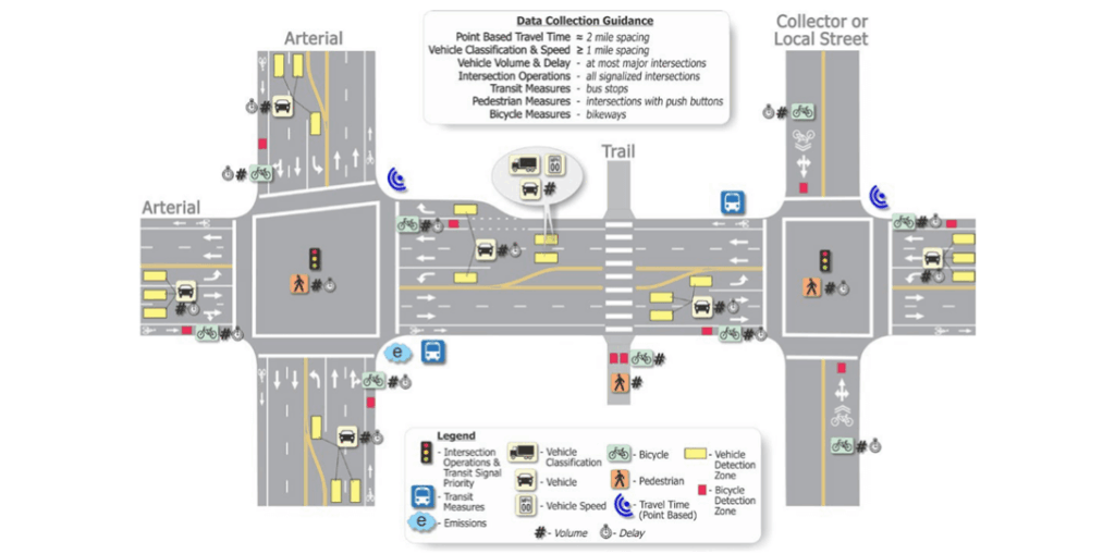
Acquiring Transportation Mapping Data

To effectively utilize geospatial technology for transportation planning, agencies require high-precision data on network infrastructure, surrounding environments, and population characteristics. While sourcing such data can present challenges, several methods exist to obtain the necessary information for comprehensive transportation mapping.

1. First-Party Data Collection

Transportation departments typically maintain proprietary datasets collected through internal operations. These may include network performance metrics—such as subway ridership figures or bus stop utilization rates—which provide invaluable insights into system-specific dynamics. Such hyper-local data often cannot be obtained from external sources.

However, first-party data has limitations. Many critical datasets required for network analysis (e.g., land cover data for site suitability assessments) are not routinely updated by transportation agencies, forcing planners to work with outdated information or generate it independently. Additionally, while historical network plans may exist, they often require modernization. For instance, sidewalk networks documented in paper maps must be digitized and updated to reflect current conditions before they can be utilized in GIS applications.

2. Manual Digitization

When usable digital data is unavailable, agencies may resort to manually digitizing paper maps or aerial imagery. Most GIS platforms offer tools for tracing and georeferencing physical features from raster images, converting them into analyzable vector data.

Although effective for small-scale projects, manual digitization is labor-intensive and cost-prohibitive for large datasets. The process demands significant time from skilled GIS professionals, and the resulting data may become outdated during the digitization period. For example, Collier County, Florida’s GIS team spent four years digitizing all driveways and access roads—a dataset that was already partially obsolete upon completion.

While manual digitization remains useful for targeted updates and gap-filling, it is not a scalable solution for maintaining comprehensive, up-to-date transportation networks.

AI-Powered Mapping Solutions

Modern AI technology is transforming how transportation planning departments acquire and maintain geospatial data, addressing longstanding challenges in the field. Tasks that previously required weeks, months, or even years of manual effort by GIS specialists can now be completed in a fraction of the time. This efficiency allows professionals to focus on higher-value analytical and strategic planning work.

Nazru’s advanced AI mapping platform leverages high-resolution imagery from our global partner network to automatically extract critical real-world features at scale. Unlike conventional automation tools, our AI-powered system delivers precision and quality comparable to manual digitization by trained GIS experts. Additionally, Nazru’s integrated change detection capabilities continuously monitor and incorporate infrastructure updates, ensuring GIS teams always work with the most current and reliable community data.

 A sample of detailed land cover data extracted by Nazru in Orlando, Florida, USA, a valuable input to infrastructure development and planning
Tree-canopy
Median-with-tree
Marked-bike-lane
Through-lane
Middle-turn-lane
Right-turn-lane
Left-turn-lane
Shoulder
Painted-madian
Raised-median
Planting-strip

 To further explore how AI can revolutionize your organization’s transportation mapping, please contact our team of experts. Our in-house licensed planner is available to assist you in scoping new projects, implementing advanced geospatial strategies, and sharing insights on how other communities are utilizing AI-powered data solutions. Reach out to us here.

Explore Nazru’s advanced transportation planning solutions.