High‑Resolution Urban Infrastructure Mapping – Hong Kong (25cm) & Santiago (40cm)
Locations: Hong Kong Special Administrative Region, China (25cm) – Santiago, Metropolitan Region, Chile (40cm)
Imagery type: Ultra‑high resolution aerial or satellite imagery
Output formats: Polygon (Hong Kong – 38 classes) – Polyline (Santiago – 18 classes) + Polygon (Santiago – 22 classes)
Project Overview
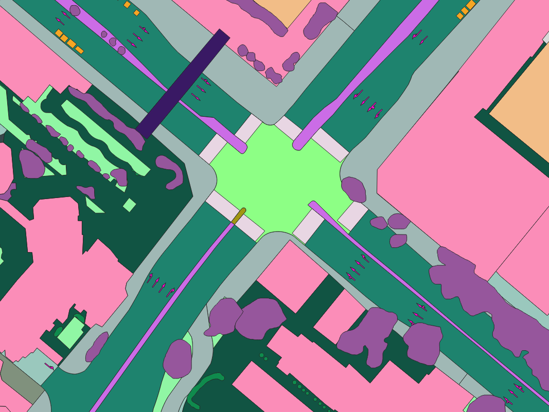
Nazru’s AI platform was deployed to produce high‑precision vector maps for two major cities – Hong Kong and Santiago – using ultra‑high resolution satellite/aerial imagery. The Hong Kong project (25cm resolution) focused entirely on polygon extraction with 38 classes covering buildings, roads, driveways, water, sport‑grounds, pavement, bridges, sidewalks, bareland, shrub, forest, parking, grass, railway, swimming‑pools, crosswalks (5 types), solid keep‑clear areas, refuge islands, ADA warning pads, box junctions, painted speed bumps, painted road markings (arrows, words, symbols, speed), painted/vegetated/raised medians, gore areas, and intersection types (stop‑controlled, signal‑controlled, uncontrolled). The Santiago project (40cm resolution) was divided into 18 polyline classes (stop‑line, through‑lane, bike‑lane, left‑right‑turn‑lane, left‑through‑lane, middle‑turn‑lane, right‑turn‑lane, slip‑turn‑lane, shoulder, right‑through‑lane, edge‑of‑pavement, driveway‑centerline, sidewalk‑centerline, yellow‑road‑line, white‑road‑line, back‑of‑curb, left‑turn‑lane, non‑traffic‑line) and 22 polygon classes (continental‑crosswalk, standard‑crosswalk, ladder‑crosswalk, mid‑block‑crosswalk, other‑crosswalk, stop‑controlled‑intersection, signal‑controlled‑intersection, uncontrolled‑intersection, painted‑road‑marking‑arrow, painted‑road‑marking‑word, painted‑road‑marking‑symbol, painted‑road‑marking‑speed, painted‑median, vegetated‑median, raised‑median, gore‑area, ADA‑warning‑pad, box‑junction‑area, painted‑speed‑bump, solid‑keep‑clear‑area, refuge‑island, no‑parking‑area). These datasets support autonomous navigation, urban planning, transportation management, and infrastructure asset mapping.
The Challenge
Mapping two densely built urban environments at sub‑metre resolution presents distinct challenges:
Hong Kong (25cm):
Extreme vertical density, narrow streets, and steep terrain.
Complex road geometry with intricate lane configurations and intersection designs.
Dense pedestrian infrastructure (5 crosswalk types, ADA pads, refuge islands, keep‑clear areas).
Diverse land use (high‑rise buildings, parks, water bodies, railways, parking lots).
Need for polygon‑only representation of 38 fine‑grained classes.
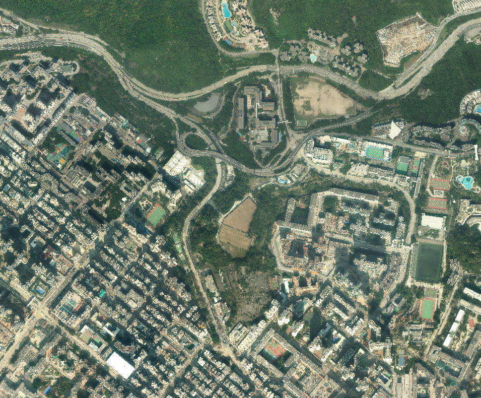
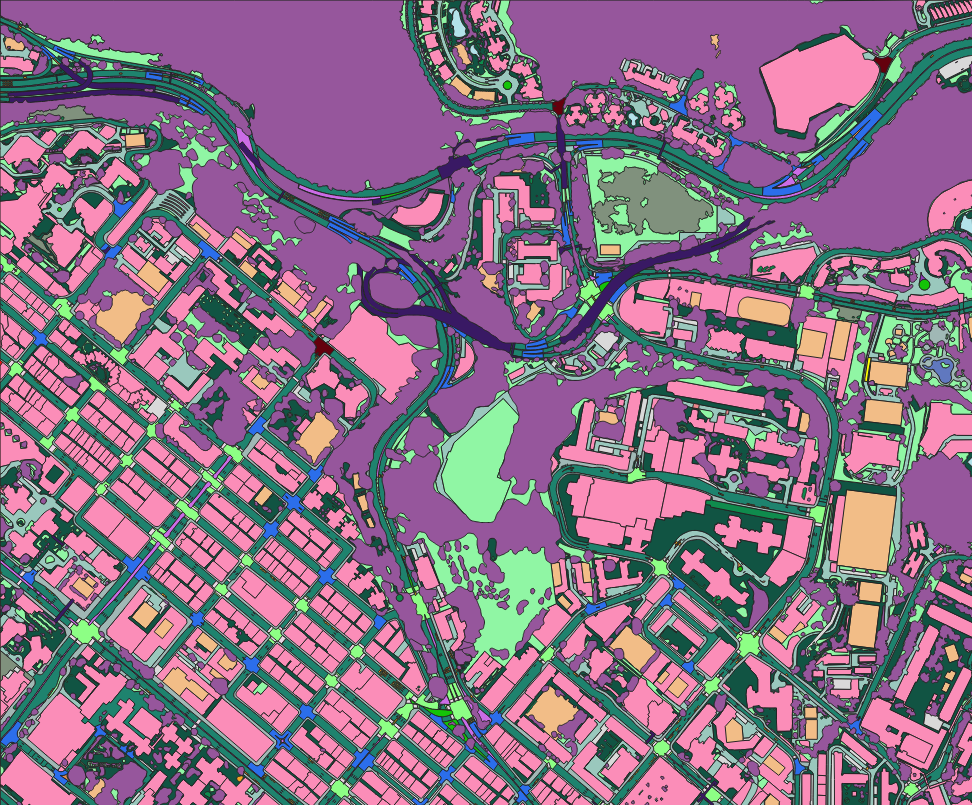
Ultra‑high resolution (25cm) satellite/aerial image over Hong Kong – AI‑based polygon mapping (38 classes).
Santiago (40cm):
Large metropolitan area with a complex mix of modern highways, arterial roads, and historic streets.
Extensive lane‑level features (18 polyline classes including bike‑lanes, turn‑lanes, shoulders, centerlines, yellow/white road lines).
Variety of intersection types (stop‑controlled, signal‑controlled, uncontrolled).
Safety and regulatory features (speed bumps, box junctions, no‑parking areas, ADA pads).
Need for both polyline (road geometry) and polygon (area features) outputs.
Both cities require sub‑pixel accuracy and consistent labelling across a wide range of feature types.
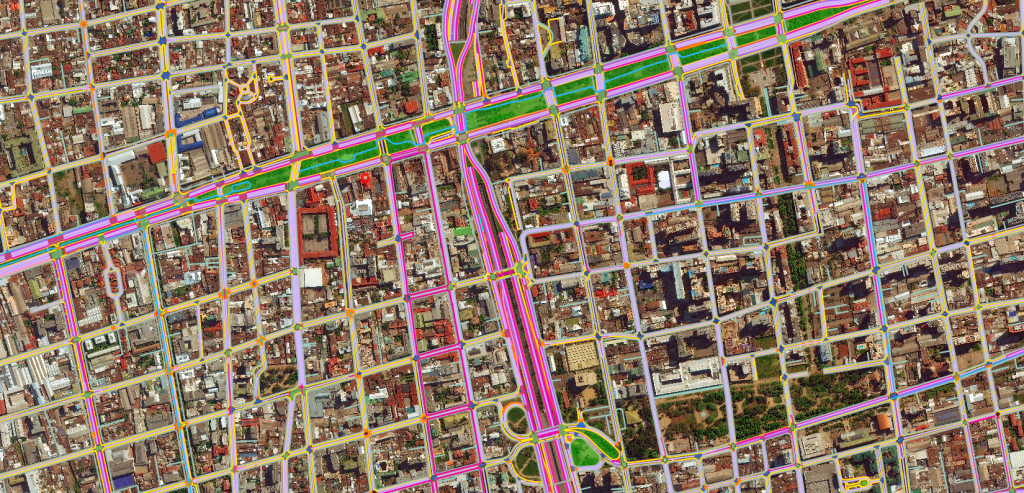
High‑resolution (40cm) satellite/aerial image over Santiago, Chile – AI‑based mapping with 18 polyline classes and 22 polygon classes.
The Nazru Solution
Nazru’s platform used deep learning for semantic and instance segmentation at 25cm (Hong Kong) and 40cm (Santiago) resolutions. The pipeline integrated multi‑spectral and panchromatic bands (where available) with a U‑Net/DeepLabV3+ backbone, optimized for each city’s specific class set and geometry type.
Hong Kong Workflow (Polygon‑only):
Orthorectification and pan‑sharpening to 25cm resolution.
Tile‑wise inference (512×512 patches) for memory efficiency.
Pixel‑wise classification of all 38 polygon classes.
Polygon vectorisation with noise filtering (minimum area threshold) and topology correction.
Quality control against high‑resolution reference data.
Santiago Workflow (Polyline + Polygon):
Orthorectification to 40cm resolution.
Dual‑branch model: one branch for pixel‑wise polygon classification, another for polyline extraction (using skeletonisation and Hough‑based line fitting).
For polylines: centerline extraction from lane markings, road edges, and curb lines.
For polygons: clean, topologically correct area features.
Quality control against field‑collected data.
Both workflows were deployed on GPU clusters for batch processing of large city‑wide datasets.
Key Results & Benefits
City‑wide vector maps for Hong Kong (38 polygon classes) and Santiago (18 polyline + 22 polygon classes) at unprecedented detail.
Sub‑metre accuracy – 25cm for Hong Kong, 40cm for Santiago, enabling lane‑level and building‑level precision.
Supports autonomous driving – lane markings, intersection types, crosswalks, bike‑lanes, and road lines are essential for HD maps.
Enables urban planning – accurate delineation of buildings, parking, medians, pedestrian zones, and open spaces.
Road safety assessment – detection of ADA pads, refuge islands, keep‑clear areas, and speed bumps.
Scalable – the same methodology can be applied to other cities with similar resolution and class requirements.
GIS‑ready – all outputs in Shapefile, GeoJSON, and KML formats with full attribute tables (
class,area_m2for polygons,length_mfor polylines,confidence).
Key Technologies Used
Deep learning segmentation – U‑Net, DeepLabV3+, or transformer‑based backbones (e.g., Swin Transformer) for pixel‑wise classification.
Polyline extraction – skeletonisation, Hough transform, and graph‑based centerline fitting.
Polygon vectorisation – raster‑to‑polygon conversion with topology correction and noise removal.
Data augmentation – rotation, scaling, and contrast adjustments to handle lighting variations.
Quality assurance – automated validation against reference data, IoU checks, and manual spot‑checking.