apan Multi‑City Land Cover & Road Infrastructure Mapping (Case Study)
Locations: Tokyo, Chiba, Osaka, Nabari, Sapporo, Tokushima, Nagoya, Fukuoka, Kamakura, Kikuchi, Saitama, Kobe, Hiroshima, Yokohama, Sasaguri, Omata, Sendai (Japan)
Project Overview
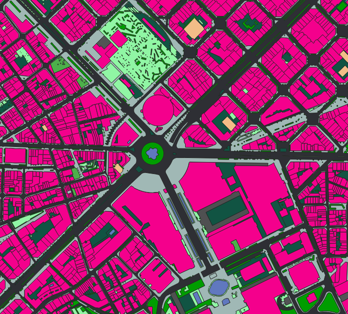
Nazru’s AI platform was deployed across 17 cities in Japan to automatically extract and classify polygon and polyline features, enriched with quality and status attributes.
Polygon classes (3):
building– standard buildingsbuilding (semi‑rigid)– industrial sheds, warehouses, or semi‑rigid structures (can be replaced by attribute)median‑strip– raised or painted central reservations (as area polygons)
Polyline classes (5):
sidewalk‑nonsidewalk– boundary between sidewalk and non‑sidewalk areaelevated‑road‑on‑water– elevated road structure over water (bridge)elevated‑road‑on‑land– elevated road structure over land (viaduct)road‑sidewalk– boundary between road and sidewalkroad‑nonroad– boundary between road and non‑road surface
Attribute flags for polygons:
occluded= ‘True/False’ (partially or fully hidden)under-cons= ‘True/False’ (under construction)uncertain= ‘True/False’ (low confidence)
Attribute flags for polylines:
occluded= ‘True/False’quasi-side= ‘True/False’ (adjacent to an ambiguous or unmarked edge)under-cons= ‘True/False’uncertain= ‘True/False’
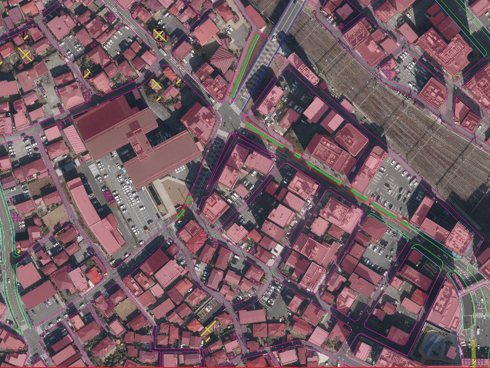
Sample image from Nagoya, Japan – AI‑based polygon and polyline extraction with attribute flags
The Challenge
Japan’s diverse urban environments (from dense Tokyo to historic Kamakura, industrial Saitama, and coastal cities like Hiroshima) required a consistent, automated method to map:
Building footprints, including distinction of semi‑rigid structures
Median strips (polygons)
Critical linear boundaries: elevated roads (over water/land), sidewalks, and road edges
Additionally, the client needed per‑feature quality flags (occlusion, construction status, uncertainty, and quasi‑side indication) to support maintenance prioritisation and manual review. Traditional manual digitisation was too slow, inconsistent, and lacked such rich attributes.
The Nazru Solution
Nazru’s platform integrated high‑resolution satellite and aerial imagery with multi‑task deep learning models. Our algorithms automatically:
Detected and extracted polygon features (buildings, semi‑rigid buildings, median strips) as clean polygons.
Detected and extracted polyline features (surface boundaries, elevated roads) as line strings.
Predicted auxiliary flags for every feature:
Polygons:
semi-rigid,occluded,under-cons,uncertainPolylines:
occluded,quasi-side,under-cons,uncertain
Geolocated all features with sub‑metre accuracy.
Key Results & Benefits
First‑time, consistent multi‑city dataset across 17 Japanese cities – unified schema for all locations.
Clear separation of standard buildings from semi‑rigid structures, median strips, and five types of linear boundaries.
Rich attribute set enabling quality‑aware workflows:
occluded– flag hidden features for re‑capture or manual editing.under-cons– identify construction zones for temporal filtering.uncertain– prioritise low‑confidence features for human verification.quasi-side(polylines) – highlight ambiguous road edges.semi-rigid(polygons) – distinguish industrial sheds from permanent buildings.
Automated, scalable workflow – reduces manual effort by >90% compared to traditional digitisation.
Ready‑to‑use GIS outputs – Shapefile, GeoJSON, KML with full attribute tables.
Key Technologies Used
AI‑based semantic segmentation – pixel‑level classification for polygons.
AI‑based edge detection and vectorisation – for polyline extraction.
Multi‑task deep learning – simultaneous prediction of class, geometry, and auxiliary flags (occluded, quasi‑side, under‑cons, uncertain, semi‑rigid).
Confidence‑based filtering –
uncertainflag supports semi‑automated quality control.Context‑aware occlusion detection – identifies features hidden by trees, shadows, or other objects.
Transfer learning – adapted to 17 different urban morphologies across Japan.
Output Formats
Polygon layer:
Formats: Shapefile, GeoJSON, KML
Attributes:
class,semi-rigid(0/1),occluded(0/1),under-cons(0/1),uncertain(0/1),area_m2
Polyline layer:
Formats: Shapefile, GeoJSON, KML
Attributes:
class,occluded(0/1),quasi-side(0/1),under-cons(0/1),uncertain(0/1).
No raster outputs unless requested.